Bátaszék geodata
Bátaszék (Tolna) is a populated place; located in Hungary in Europe/Budapest (GMT+2) time zone. With population of 6,820 people, there are 226 cities with bigger population in this country. Compared to other cities in Hungary, 95.9% of cities are located further ↑North; 72.7% of cities are located further →East and 87.7% of cities have higher elevation than Bátaszék. Note1


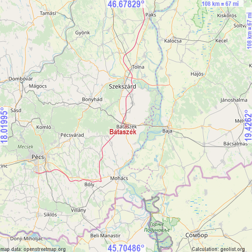
Bátaszék GPS coordinates[2]
46° 11' 37.428" North, 18° 43' 23.052" East
| Map corner | latitude | longitude |
|---|---|---|
| Upper-left | 46.67829°, | 18.01995° |
| Center: | 46.19373°, | 18.72307° |
| Lower-right: | 45.70486°, | 19.4262° |
| Map W x H: | 108.2×108.2 km | = 67.2×67.2mi |
| max Lat: | 48.46667° ⇑95.9% North |
| Bátaszék: | 46.19373° |
| min Lat: | ⇓4.1% South 45.79108° |
| min Long | Bátaszék | max Long |
| 16.27358° | 18.72307° | 22.68096° |
| W 27.3%⇐ | ⇒72.7% E |
Elevation
Elevation of Bátaszék is 88 m = 289 ft, and this is 41.7 m = 137 ft below average elevation for this country.
| Max E: |
444 m = 1457 ft | 87.7% |
| Avg. | 129.7 m = 426 ft | |
| Bátaszék | 88 m = 289 ft | |
Min E: |
71 m = 233 ft | 12.3% |
See also: Hungary elevation on elevation.city.
Geographical zone
Bátaszék is located in North temperate zone (between Tropic of Cancer and the Arctic Circle). Distance of this North polar circle is 2264.9 km =1407.3 mi to North.| Distance of | km | miles | from Bátaszék |
|---|---|---|---|
| North Pole | 4870.8 | 3026.6 | to North |
| Arctic Circle | 2264.9 | 1407.3 | to North |
| Tropic Cancer | 2530.3 | 1572.3 | to South |
| Equator | 5136.3 | 3191.5 | to South |


Nearby cities:
15 places around Bátaszék: (largest is in red/bold)
• Baja
17.7 km =11 mi,  93°
93°
• Bonyhád
18.9 km =11.7 mi,  308°
308°
• Báta
8.1 km =5 mi,  153°
153°
• Decs
10.5 km =6.5 mi,  15°
15°
• Dunaszekcső
12.1 km =7.5 mi,  166°
166°
• Hidas
18.9 km =11.7 mi,  291°
291°
• Lánycsók
22.3 km =13.9 mi,  199°
199°
• Mecseknádasd
19.7 km =12.2 mi,  280°
280°
• Nagybaracska
21.9 km =13.6 mi,  140°
140°
• Nagymányok
22.7 km =14.1 mi, 294°
• Szekszárd
17.4 km =10.8 mi,  356°
356°
• Szentgálpuszta
21.5 km =13.4 mi,  339°
339°
• Vaskút
22.3 km =13.9 mi,  115°
115°
• Érsekcsanád
21.2 km =13.2 mi,  71°
71°
• Őcsény
13.6 km =8.5 mi,  11°
11°
Sources, notices
• [Note1] Compared only with cities in Hungary existing in our database
• [Src1] Map data: © OpenStreetMap contributors (CC-BY-SA)
• [Src2] Other city data from geonames.org with taken over terms of usage.
• [Src3] Geographical zone / Annual Mean Temperature by Robert A. Rohde @ Wikipedia
