Nagybaracska geodata
Nagybaracska (Bács-Kiskun) is a populated place; located in Hungary in Europe/Budapest (GMT+2) time zone. With population of 2,445 people, there are 632 cities with bigger population in this country. Compared to other cities in Hungary, 97.9% of cities are located further ↑North; 68.5% of cities are located further →East and 85.5% of cities have higher elevation than Nagybaracska. Note1


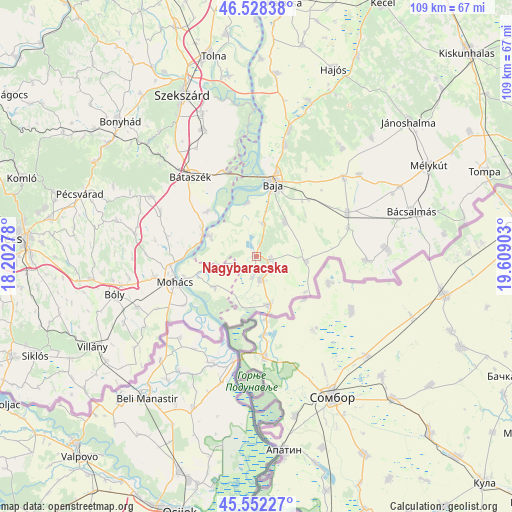
Nagybaracska GPS coordinates[2]
46° 2' 32.928" North, 18° 54' 21.24" East
| Map corner | latitude | longitude |
|---|---|---|
| Upper-left | 46.52838°, | 18.20278° |
| Center: | 46.04248°, | 18.9059° |
| Lower-right: | 45.55227°, | 19.60903° |
| Map W x H: | 108.5×108.5 km | = 67.4×67.4mi |
| max Lat: | 48.46667° ⇑97.9% North |
| Nagybaracska: | 46.04248° |
| min Lat: | ⇓2.1% South 45.79108° |
| min Long | Nagybaracska | max Long |
| 16.27358° | 18.9059° | 22.68096° |
| W 31.5%⇐ | ⇒68.5% E |
Elevation
Elevation of Nagybaracska is 90 m = 295 ft, and this is 39.7 m = 130 ft below average elevation for this country.
| Max E: |
444 m = 1457 ft | 85.5% |
| Avg. | 129.7 m = 426 ft | |
| Nagybaracska | 90 m = 295 ft | |
Min E: |
71 m = 233 ft | 14.5% |
See also: Hungary elevation on elevation.city.
Geographical zone
Nagybaracska is located in North temperate zone (between Tropic of Cancer and the Arctic Circle). Distance of this North polar circle is 2281.7 km =1417.8 mi to North.| Distance of | km | miles | from Nagybaracska |
|---|---|---|---|
| North Pole | 4887.6 | 3037 | to North |
| Arctic Circle | 2281.7 | 1417.8 | to North |
| Tropic Cancer | 2513.5 | 1561.8 | to South |
| Equator | 5119.4 | 3181 | to South |


Nearby cities:
15 places around Nagybaracska: (largest is in red/bold)
• Baja
16 km =9.9 mi,  13°
13°
• Bácsbokod
21.4 km =13.3 mi,  64°
64°
• Báta
14.2 km =8.8 mi,  312°
312°
• Bátaszék
21.9 km =13.6 mi,  320°
320°
• Csávoly
24.7 km =15.3 mi,  48°
48°
• Dunaszekcső
12.4 km =7.7 mi,  293°
293°
• Dávod
5.4 km =3.4 mi,  170°
170°
• Gara
10.6 km =6.6 mi,  96°
96°
• Hercegszántó
10.6 km =6.6 mi, 165°
• Katymár
23.4 km =14.5 mi,  92°
92°
• Lánycsók
22.1 km =13.7 mi,  259°
259°
• Mohács
17.9 km =11.1 mi,  251°
251°
• Sükösd
27.5 km =17.1 mi, 14°
• Vaskút
9.5 km =5.9 mi,  40°
40°
• Érsekcsanád
24.2 km =15 mi, 14°
Sources, notices
• [Note1] Compared only with cities in Hungary existing in our database
• [Src1] Map data: © OpenStreetMap contributors (CC-BY-SA)
• [Src2] Other city data from geonames.org with taken over terms of usage.
• [Src3] Geographical zone / Annual Mean Temperature by Robert A. Rohde @ Wikipedia
