Leányfalu geodata
Leányfalu (Pest) is a populated place; located in Hungary in Europe/Budapest (GMT+2) time zone. With population of 2,534 people, there are 608 cities with bigger population in this country. Compared to other cities in Hungary, 71.7% of cities are located further ↓South; 60.4% of cities are located further →East and 56.8% of cities have lower elevation than Leányfalu. Note1


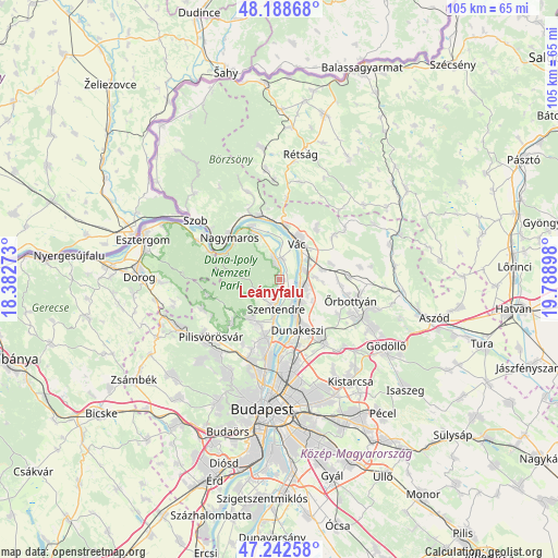
Leányfalu GPS coordinates[2]
47° 43' 4.008" North, 19° 5' 9.06" East
| Map corner | latitude | longitude |
|---|---|---|
| Upper-left | 48.18868°, | 18.38273° |
| Center: | 47.71778°, | 19.08585° |
| Lower-right: | 47.24258°, | 19.78898° |
| Map W x H: | 105.2×105.2 km | = 65.4×65.4mi |
| max Lat: | 48.46667° ⇑28.3% North |
| Leányfalu: | 47.71778° |
| min Lat: | ⇓71.7% South 45.79108° |
| min Long | Leányfalu | max Long |
| 16.27358° | 19.08585° | 22.68096° |
| W 39.6%⇐ | ⇒60.4% E |
Elevation
Elevation of Leányfalu is 123 m = 404 ft, and this is 6.7 m = 22 ft below average elevation for this country.
| Max E: |
444 m = 1457 ft | 43.2% |
| Avg. | 129.7 m = 426 ft | |
| Leányfalu | 123 m = 404 ft | |
Min E: |
71 m = 233 ft | 56.8% |
See also: Hungary elevation on elevation.city.
Geographical zone
Leányfalu is located in North temperate zone (between Tropic of Cancer and the Arctic Circle). Distance of this North polar circle is 2095.5 km =1302.1 mi to North.| Distance of | km | miles | from Leányfalu |
|---|---|---|---|
| North Pole | 4701.3 | 2921.3 | to North |
| Arctic Circle | 2095.5 | 1302.1 | to North |
| Tropic Cancer | 2699.8 | 1677.6 | to South |
| Equator | 5305.7 | 3296.8 | to South |


Nearby cities:
15 places around Leányfalu: (largest is in red/bold)
• Budakalász
11.6 km =7.2 mi,  193°
193°
• Csobánka
12.2 km =7.6 mi,  229°
229°
• Dunabogdány
8.7 km =5.4 mi,  337°
337°
• Dunakeszi
9.9 km =6.2 mi,  156°
156°
• Göd
5.3 km =3.3 mi,  136°
136°
• Kosd
12.2 km =7.6 mi,  34°
34°
• Nagykovácsi
9.1 km =5.7 mi,  214°
214°
• Pomáz
9.5 km =5.9 mi, 207°
• Szentendre
5.4 km =3.4 mi, 188°
• Sződ
6.4 km =4 mi,  83°
83°
• Sződliget
4.9 km =3 mi,  70°
70°
• Tahitótfalu
3.7 km =2.3 mi,  16°
16°
• Verőce
12.5 km =7.8 mi, 342°
• Visegrád
11.4 km =7.1 mi,  311°
311°
• Vác
7.5 km =4.7 mi, 30°
Sources, notices
• [Note1] Compared only with cities in Hungary existing in our database
• [Src1] Map data: © OpenStreetMap contributors (CC-BY-SA)
• [Src2] Other city data from geonames.org with taken over terms of usage.
• [Src3] Geographical zone / Annual Mean Temperature by Robert A. Rohde @ Wikipedia
