Dunabogdány geodata
Dunabogdány (Pest) is a populated place; located in Hungary in Europe/Budapest (GMT+2) time zone. With population of 3,059 people, there are 485 cities with bigger population in this country. Compared to other cities in Hungary, 76.7% of cities are located further ↓South; 62.2% of cities are located further →East and 65.5% of cities have higher elevation than Dunabogdány. Note1


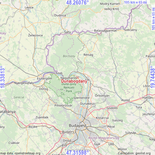
Dunabogdány GPS coordinates[2]
47° 47' 25.872" North, 19° 2' 28.5" East
| Map corner | latitude | longitude |
|---|---|---|
| Upper-left | 48.26076°, | 18.33813° |
| Center: | 47.79052°, | 19.04125° |
| Lower-right: | 47.31598°, | 19.74438° |
| Map W x H: | 105×105 km | = 65.2×65.2mi |
| max Lat: | 48.46667° ⇑23.3% North |
| Dunabogdány: | 47.79052° |
| min Lat: | ⇓76.7% South 45.79108° |
| min Long | Dunabogdány | max Long |
| 16.27358° | 19.04125° | 22.68096° |
| W 37.8%⇐ | ⇒62.2% E |
Elevation
Elevation of Dunabogdány is 106 m = 348 ft, and this is 23.7 m = 78 ft below average elevation for this country.
| Max E: |
444 m = 1457 ft | 65.5% |
| Avg. | 129.7 m = 426 ft | |
| Dunabogdány | 106 m = 348 ft | |
Min E: |
71 m = 233 ft | 34.5% |
See also: Hungary elevation on elevation.city.
Geographical zone
Dunabogdány is located in North temperate zone (between Tropic of Cancer and the Arctic Circle). Distance of this North polar circle is 2087.4 km =1297 mi to North.| Distance of | km | miles | from Dunabogdány |
|---|---|---|---|
| North Pole | 4693.3 | 2916.3 | to North |
| Arctic Circle | 2087.4 | 1297 | to North |
| Tropic Cancer | 2707.9 | 1682.6 | to South |
| Equator | 5313.8 | 3301.8 | to South |


Nearby cities:
15 places around Dunabogdány: (largest is in red/bold)
• Göd
13.8 km =8.6 mi,  149°
149°
• Kismaros
5.9 km =3.7 mi,  332°
332°
• Kosd
10.4 km =6.5 mi,  79°
79°
• Leányfalu
8.7 km =5.4 mi,  157°
157°
• Nagymaros
6.1 km =3.8 mi,  272°
272°
• Pilismarót
12.4 km =7.7 mi, 266°
• Pilisszentkereszt
15 km =9.3 mi,  222°
222°
• Szentendre
13.7 km =8.5 mi,  169°
169°
• Szob
13.2 km =8.2 mi,  284°
284°
• Sződ
12.1 km =7.5 mi,  127°
127°
• Sződliget
10.2 km =6.3 mi, 129°
• Tahitótfalu
6.3 km =3.9 mi,  135°
135°
• Verőce
3.8 km =2.4 mi,  352°
352°
• Visegrád
5.3 km =3.3 mi,  263°
263°
• Vác
7.3 km =4.5 mi,  102°
102°
Sources, notices
• [Note1] Compared only with cities in Hungary existing in our database
• [Src1] Map data: © OpenStreetMap contributors (CC-BY-SA)
• [Src2] Other city data from geonames.org with taken over terms of usage.
• [Src3] Geographical zone / Annual Mean Temperature by Robert A. Rohde @ Wikipedia
