Visegrád geodata
Visegrád (Pest) is a populated place; located in Hungary in Europe/Budapest (GMT+2) time zone. With population of 1,713 people, there are 853 cities with bigger population in this country. Compared to other cities in Hungary, 76.4% of cities are located further ↓South; 65.2% of cities are located further →East and 59.7% of cities have higher elevation than Visegrád. Note1


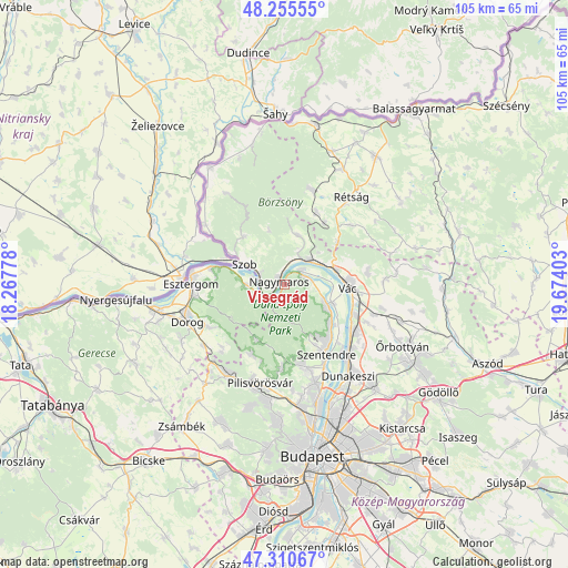
Visegrád GPS coordinates[2]
47° 47' 6.936" North, 18° 58' 15.24" East
| Map corner | latitude | longitude |
|---|---|---|
| Upper-left | 48.25555°, | 18.26778° |
| Center: | 47.78526°, | 18.9709° |
| Lower-right: | 47.31067°, | 19.67403° |
| Map W x H: | 105.1×105.1 km | = 65.3×65.3mi |
| max Lat: | 48.46667° ⇑23.6% North |
| Visegrád: | 47.78526° |
| min Lat: | ⇓76.4% South 45.79108° |
| min Long | Visegrád | max Long |
| 16.27358° | 18.9709° | 22.68096° |
| W 34.8%⇐ | ⇒65.2% E |
Elevation
Elevation of Visegrád is 110 m = 361 ft, and this is 19.7 m = 65 ft below average elevation for this country.
| Max E: |
444 m = 1457 ft | 59.7% |
| Avg. | 129.7 m = 426 ft | |
| Visegrád | 110 m = 361 ft | |
Min E: |
71 m = 233 ft | 40.3% |
See also: Hungary elevation on elevation.city.
Geographical zone
Visegrád is located in North temperate zone (between Tropic of Cancer and the Arctic Circle). Distance of this North polar circle is 2088 km =1297.4 mi to North.| Distance of | km | miles | from Visegrád |
|---|---|---|---|
| North Pole | 4693.8 | 2916.6 | to North |
| Arctic Circle | 2088 | 1297.4 | to North |
| Tropic Cancer | 2707.3 | 1682.2 | to South |
| Equator | 5313.2 | 3301.5 | to South |


Nearby cities:
15 places around Visegrád: (largest is in red/bold)
• Dunabogdány
5.3 km =3.3 mi,  83°
83°
• Kesztölc
15 km =9.3 mi,  237°
237°
• Kismaros
6.3 km =3.9 mi,  23°
23°
• Leányfalu
11.4 km =7.1 mi,  131°
131°
• Nagykovácsi
15.4 km =9.6 mi,  167°
167°
• Nagymaros
1.2 km =0.7 mi,  315°
315°
• Pilismarót
7.1 km =4.4 mi,  269°
269°
• Pilisszentkereszt
11.5 km =7.1 mi,  205°
205°
• Pilisszántó
14.3 km =8.9 mi, 205°
• Szentendre
15.1 km =9.4 mi,  148°
148°
• Szob
8.4 km =5.2 mi,  296°
296°
• Sződliget
14.4 km =8.9 mi,  113°
113°
• Tahitótfalu
10.4 km =6.5 mi, 112°
• Verőce
6.5 km =4 mi,  47°
47°
• Vác
12.4 km =7.7 mi,  94°
94°
Sources, notices
• [Note1] Compared only with cities in Hungary existing in our database
• [Src1] Map data: © OpenStreetMap contributors (CC-BY-SA)
• [Src2] Other city data from geonames.org with taken over terms of usage.
• [Src3] Geographical zone / Annual Mean Temperature by Robert A. Rohde @ Wikipedia
