Sződ geodata
Sződ (Pest) is a populated place; located in Hungary in Europe/Budapest (GMT+2) time zone. With population of 3,059 people, there are 485 cities with bigger population in this country. Compared to other cities in Hungary, 72.3% of cities are located further ↓South; 57.5% of cities are located further →East and 59.7% of cities have higher elevation than Sződ. Note1


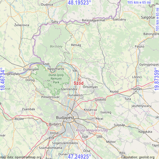
Sződ GPS coordinates[2]
47° 43' 27.804" North, 19° 10' 13.656" East
| Map corner | latitude | longitude |
|---|---|---|
| Upper-left | 48.19523°, | 18.46734° |
| Center: | 47.72439°, | 19.17046° |
| Lower-right: | 47.24925°, | 19.87359° |
| Map W x H: | 105.2×105.2 km | = 65.4×65.4mi |
| max Lat: | 48.46667° ⇑27.7% North |
| Sződ: | 47.72439° |
| min Lat: | ⇓72.3% South 45.79108° |
| min Long | Sződ | max Long |
| 16.27358° | 19.17046° | 22.68096° |
| W 42.5%⇐ | ⇒57.5% E |
Elevation
Elevation of Sződ is 110 m = 361 ft, and this is 19.7 m = 65 ft below average elevation for this country.
| Max E: |
444 m = 1457 ft | 59.7% |
| Avg. | 129.7 m = 426 ft | |
| Sződ | 110 m = 361 ft | |
Min E: |
71 m = 233 ft | 40.3% |
See also: Hungary elevation on elevation.city.
Geographical zone
Sződ is located in North temperate zone (between Tropic of Cancer and the Arctic Circle). Distance of this North polar circle is 2094.7 km =1301.6 mi to North.| Distance of | km | miles | from Sződ |
|---|---|---|---|
| North Pole | 4700.6 | 2920.8 | to North |
| Arctic Circle | 2094.7 | 1301.6 | to North |
| Tropic Cancer | 2700.5 | 1678 | to South |
| Equator | 5306.5 | 3297.3 | to South |


Nearby cities:
15 places around Sződ: (largest is in red/bold)
• Dunabogdány
12.1 km =7.5 mi,  307°
307°
• Dunakeszi
10.1 km =6.3 mi,  193°
193°
• Erdőkertes
11.8 km =7.3 mi,  119°
119°
• Fót
11.9 km =7.4 mi,  173°
173°
• Göd
5.3 km =3.3 mi,  210°
210°
• Kosd
9.3 km =5.8 mi,  3°
3°
• Leányfalu
6.4 km =4 mi,  263°
263°
• Nagykovácsi
14.2 km =8.8 mi,  234°
234°
• Pomáz
14 km =8.7 mi, 229°
• Szentendre
9.4 km =5.8 mi, 229°
• Sződliget
1.9 km =1.2 mi,  297°
297°
• Tahitótfalu
6 km =3.7 mi, 298°
• Veresegyház
12.8 km =8 mi,  133°
133°
• Vác
6.3 km =3.9 mi,  335°
335°
• Őrbottyán
9.3 km =5.8 mi, 116°
Sources, notices
• [Note1] Compared only with cities in Hungary existing in our database
• [Src1] Map data: © OpenStreetMap contributors (CC-BY-SA)
• [Src2] Other city data from geonames.org with taken over terms of usage.
• [Src3] Geographical zone / Annual Mean Temperature by Robert A. Rohde @ Wikipedia
