Győr geodata
Győr (Győr-Moson-Sopron) is a seat of a first-order administrative division; located in Hungary in Europe/Budapest (GMT+2) time zone. With population of 128,265 people, there are 7 cities with bigger population in this country. Compared to other cities in Hungary, 68.9% of cities are located further ↓South; 90.2% of cities are located further →East and 56.3% of cities have lower elevation than Győr. Note1


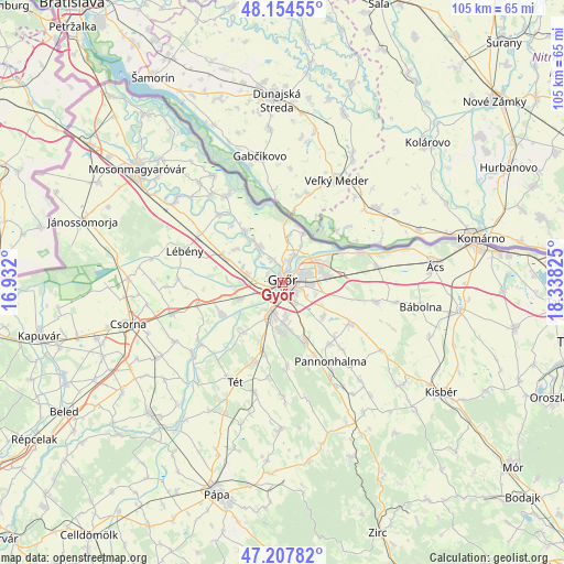
Győr GPS coordinates[2]
47° 40' 59.988" North, 17° 38' 6.432" East
| Map corner | latitude | longitude |
|---|---|---|
| Upper-left | 48.15455°, | 16.932° |
| Center: | 47.68333°, | 17.63512° |
| Lower-right: | 47.20782°, | 18.33825° |
| Map W x H: | 105.3×105.3 km | = 65.4×65.4mi |
| max Lat: | 48.46667° ⇑31.1% North |
| Győr: | 47.68333° |
| min Lat: | ⇓68.9% South 45.79108° |
| min Long | Győr | max Long |
| 16.27358° | 17.63512° | 22.68096° |
| W 9.8%⇐ | ⇒90.2% E |
Elevation
Elevation of Győr is 122 m = 400 ft, and this is 7.7 m = 25 ft below average elevation for this country.
| Max E: |
444 m = 1457 ft | 43.7% |
| Avg. | 129.7 m = 426 ft | |
| Győr | 122 m = 400 ft | |
Min E: |
71 m = 233 ft | 56.3% |
See also: Győr elevation on elevation.city.
Geographical zone
Győr is located in North temperate zone (between Tropic of Cancer and the Arctic Circle). Distance of this North polar circle is 2099.3 km =1304.4 mi to North.| Distance of | km | miles | from Győr |
|---|---|---|---|
| North Pole | 4705.2 | 2923.7 | to North |
| Arctic Circle | 2099.3 | 1304.4 | to North |
| Tropic Cancer | 2696 | 1675.2 | to South |
| Equator | 5301.9 | 3294.4 | to South |


Nearby cities:
15 places around Győr: (largest is in red/bold)
• Abda
6.9 km =4.3 mi,  280°
280°
• Bőny
18 km =11.2 mi,  101°
101°
• Győrszemere
15.5 km =9.6 mi,  200°
200°
• Győrújbarát
8.6 km =5.3 mi,  173°
173°
• Lébény
19.2 km =11.9 mi,  287°
287°
• Mosonszentmiklós
16.3 km =10.1 mi, 287°
• Nyúl
11.1 km =6.9 mi,  158°
158°
• Pannonhalma
17.4 km =10.8 mi,  148°
148°
• Pér
15.1 km =9.4 mi,  121°
121°
• Rábacsécsény
19.2 km =11.9 mi,  235°
235°
• Rábapatona
12.9 km =8 mi, 243°
• Rábaszentmihály
19.2 km =11.9 mi,  232°
232°
• Töltéstava
9.8 km =6.1 mi,  130°
130°
• Ásványráró
19.2 km =11.9 mi,  326°
326°
• Öttevény
11.9 km =7.4 mi, 289°
Sources, notices
• [Note1] Compared only with cities in Hungary existing in our database
• [Src1] Map data: © OpenStreetMap contributors (CC-BY-SA)
• [Src2] Other city data from geonames.org with taken over terms of usage.
• [Src3] Geographical zone / Annual Mean Temperature by Robert A. Rohde @ Wikipedia
