Oroszlány geodata
Oroszlány (Komárom-Esztergom) is a seat of a second-order administrative division; located in Hungary in Europe/Budapest (GMT+2) time zone. With population of 20,271 people, there are 85 cities with bigger population in this country. Compared to other cities in Hungary, 54.6% of cities are located further ↓South; 80.6% of cities are located further →East and 88.5% of cities have lower elevation than Oroszlány. Note1


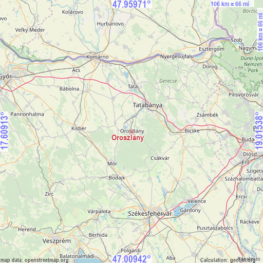
Oroszlány GPS coordinates[2]
47° 29' 12.156" North, 18° 18' 44.1" East
| Map corner | latitude | longitude |
|---|---|---|
| Upper-left | 47.95971°, | 17.60913° |
| Center: | 47.48671°, | 18.31225° |
| Lower-right: | 47.00942°, | 19.01538° |
| Map W x H: | 105.7×105.7 km | = 65.7×65.7mi |
| max Lat: | 48.46667° ⇑45.4% North |
| Oroszlány: | 47.48671° |
| min Lat: | ⇓54.6% South 45.79108° |
| min Long | Oroszlány | max Long |
| 16.27358° | 18.31225° | 22.68096° |
| W 19.4%⇐ | ⇒80.6% E |
Elevation
Elevation of Oroszlány is 182 m = 597 ft, and this is 52.3 m = 172 ft above average elevation for this country.
| Max E: |
444 m = 1457 ft | 11.5% |
| Oroszlány | 182 m 597 ft | |
| Avg. | 129.7 m = 426 ft | |
Min E: |
71 m = 233 ft | 88.5% |
See also: Hungary elevation on elevation.city.
Geographical zone
Oroszlány is located in North temperate zone (between Tropic of Cancer and the Arctic Circle). Distance of this North polar circle is 2121.1 km =1318 mi to North.| Distance of | km | miles | from Oroszlány |
|---|---|---|---|
| North Pole | 4727 | 2937.2 | to North |
| Arctic Circle | 2121.1 | 1318 | to North |
| Tropic Cancer | 2674.1 | 1661.6 | to South |
| Equator | 5280 | 3280.8 | to South |


Nearby cities:
15 places around Oroszlány: (largest is in red/bold)
• Baj
18.1 km =11.2 mi,  12°
12°
• Bodajk
19.1 km =11.9 mi,  198°
198°
• Bokod
4.9 km =3 mi,  276°
276°
• Csákvár
15.6 km =9.7 mi,  132°
132°
• Császár
12.8 km =8 mi, 275°
• Ete
18.5 km =11.5 mi,  285°
285°
• Kecskéd
4 km =2.5 mi,  356°
356°
• Kocs
15.3 km =9.5 mi,  331°
331°
• Környe
6.7 km =4.2 mi, 5°
• Mór
14.6 km =9.1 mi,  214°
214°
• Pusztavám
9.1 km =5.7 mi,  225°
225°
• Szárliget
14.1 km =8.8 mi,  76°
76°
• Tata
18.5 km =11.5 mi,  1°
1°
• Tatabánya
12.5 km =7.8 mi,  29°
29°
• Vértesszőlős
15.8 km =9.8 mi,  19°
19°
Sources, notices
• [Note1] Compared only with cities in Hungary existing in our database
• [Src1] Map data: © OpenStreetMap contributors (CC-BY-SA)
• [Src2] Other city data from geonames.org with taken over terms of usage.
• [Src3] Geographical zone / Annual Mean Temperature by Robert A. Rohde @ Wikipedia
