Bokod geodata
Bokod (Komárom-Esztergom) is a populated place; located in Hungary in Europe/Budapest (GMT+2) time zone. With population of 2,229 people, there are 699 cities with bigger population in this country. Compared to other cities in Hungary, 55% of cities are located further ↓South; 81.9% of cities are located further →East and 92.4% of cities have lower elevation than Bokod. Note1


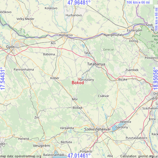
Bokod GPS coordinates[2]
47° 29' 30.696" North, 18° 14' 50.748" East
| Map corner | latitude | longitude |
|---|---|---|
| Upper-left | 47.96481°, | 17.54431° |
| Center: | 47.49186°, | 18.24743° |
| Lower-right: | 47.01461°, | 18.95056° |
| Map W x H: | 105.7×105.7 km | = 65.7×65.7mi |
| max Lat: | 48.46667° ⇑45% North |
| Bokod: | 47.49186° |
| min Lat: | ⇓55% South 45.79108° |
| min Long | Bokod | max Long |
| 16.27358° | 18.24743° | 22.68096° |
| W 18.1%⇐ | ⇒81.9% E |
Elevation
Elevation of Bokod is 201 m = 659 ft, and this is 71.3 m = 234 ft above average elevation for this country.
| Max E: |
444 m = 1457 ft | 7.6% |
| Bokod | 201 m 659 ft | |
| Avg. | 129.7 m = 426 ft | |
Min E: |
71 m = 233 ft | 92.4% |
See also: Hungary elevation on elevation.city.
Geographical zone
Bokod is located in North temperate zone (between Tropic of Cancer and the Arctic Circle). Distance of this North polar circle is 2120.6 km =1317.7 mi to North.| Distance of | km | miles | from Bokod |
|---|---|---|---|
| North Pole | 4726.5 | 2936.9 | to North |
| Arctic Circle | 2120.6 | 1317.7 | to North |
| Tropic Cancer | 2674.7 | 1662 | to South |
| Equator | 5280.6 | 3281.2 | to South |


Nearby cities:
15 places around Bokod: (largest is in red/bold)
• Baj
19.2 km =11.9 mi,  27°
27°
• Bodajk
18.7 km =11.6 mi,  183°
183°
• Császár
7.9 km =4.9 mi,  274°
274°
• Ete
13.6 km =8.5 mi,  288°
288°
• Kecskéd
5.8 km =3.6 mi,  53°
53°
• Kisbér
15.9 km =9.9 mi, 274°
• Kocs
13.1 km =8.1 mi,  349°
349°
• Környe
8.2 km =5.1 mi,  42°
42°
• Mór
13.1 km =8.1 mi,  194°
194°
• Oroszlány
4.9 km =3 mi,  96°
96°
• Pusztavám
7.1 km =4.4 mi, 192°
• Szárliget
18.8 km =11.7 mi,  81°
81°
• Tata
18.7 km =11.6 mi,  16°
16°
• Tatabánya
15.1 km =9.4 mi, 46°
• Vértesszőlős
17.5 km =10.9 mi, 34°
Sources, notices
• [Note1] Compared only with cities in Hungary existing in our database
• [Src1] Map data: © OpenStreetMap contributors (CC-BY-SA)
• [Src2] Other city data from geonames.org with taken over terms of usage.
• [Src3] Geographical zone / Annual Mean Temperature by Robert A. Rohde @ Wikipedia
