Hévízgyörk geodata
Hévízgyörk (Pest) is a populated place; located in Hungary in Europe/Budapest (GMT+2) time zone. With population of 3,101 people, there are 477 cities with bigger population in this country. Compared to other cities in Hungary, 65.2% of cities are located further ↓South; 50.2% of cities are located further ←West and 51.5% of cities have lower elevation than Hévízgyörk. Note1


Hévízgyörk GPS coordinates[2]
47° 37' 59.988" North, 19° 31' 0.012" East
| Map corner | latitude | longitude |
|---|---|---|
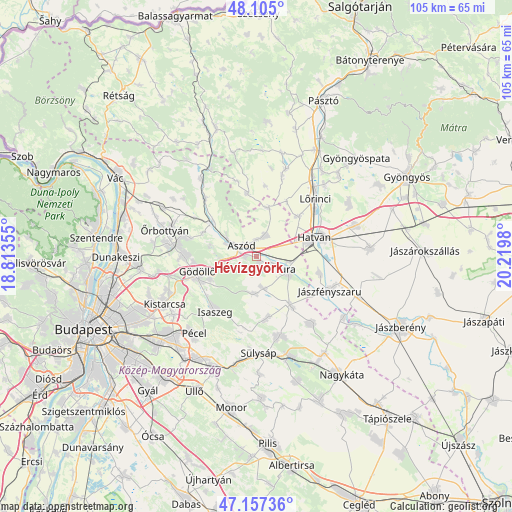
| Upper-left | 48.105°, | 18.81355° |
| Center: | 47.63333°, | 19.51667° |
| Lower-right: | 47.15736°, | 20.2198° |
| Map W x H: | 105.4×105.4 km | = 65.5×65.5mi |
| max Lat: | 48.46667° ⇑34.8% North |
| Hévízgyörk: | 47.63333° |
| min Lat: | ⇓65.2% South 45.79108° |
| min Long | Hévízgyörk | max Long |
| 16.27358° | 19.51667° | 22.68096° |
| W 50.2%⇐ | ⇒49.8% E |
Elevation
Elevation of Hévízgyörk is 117 m = 384 ft, and this is 12.7 m = 42 ft below average elevation for this country.
| Max E: |
444 m = 1457 ft | 48.5% |
| Avg. | 129.7 m = 426 ft | |
| Hévízgyörk | 117 m = 384 ft | |
Min E: |
71 m = 233 ft | 51.5% |
See also: Hungary elevation on elevation.city.
Geographical zone
Hévízgyörk is located in North temperate zone (between Tropic of Cancer and the Arctic Circle). Distance of this North polar circle is 2104.8 km =1307.9 mi to North.| Distance of | km | miles | from Hévízgyörk |
|---|---|---|---|
| North Pole | 4710.7 | 2927.1 | to North |
| Arctic Circle | 2104.8 | 1307.9 | to North |
| Tropic Cancer | 2690.4 | 1671.7 | to South |
| Equator | 5296.3 | 3291 | to South |


Nearby cities:
15 places around Hévízgyörk: (largest is in red/bold)
• Aszód
3.5 km =2.2 mi,  305°
305°
• Bag
2.5 km =1.6 mi,  270°
270°
• Domony
6.8 km =4.2 mi,  291°
291°
• Dány
12.8 km =8 mi,  170°
170°
• Galgahévíz
4.2 km =2.6 mi,  116°
116°
• Galgamácsa
11.9 km =7.4 mi, 305°
• Gödöllő
12.8 km =8 mi,  251°
251°
• Hatvan
13 km =8.1 mi,  73°
73°
• Heréd
11.9 km =7.4 mi,  47°
47°
• Iklad
7 km =4.3 mi,  300°
300°
• Kartal
4.6 km =2.9 mi,  24°
24°
• Tura
7 km =4.3 mi,  112°
112°
• Valkó
7.7 km =4.8 mi,  182°
182°
• Vácszentlászló
6.8 km =4.2 mi, 166°
• Zsámbok
12.2 km =7.6 mi,  144°
144°
Sources, notices
• [Note1] Compared only with cities in Hungary existing in our database
• [Src1] Map data: © OpenStreetMap contributors (CC-BY-SA)
• [Src2] Other city data from geonames.org with taken over terms of usage.
• [Src3] Geographical zone / Annual Mean Temperature by Robert A. Rohde @ Wikipedia
