Kartal geodata
Kartal (Pest) is a populated place; located in Hungary in Europe/Budapest (GMT+2) time zone. With population of 6,017 people, there are 252 cities with bigger population in this country. Compared to other cities in Hungary, 68.3% of cities are located further ↓South; 51.1% of cities are located further ←West and 79.1% of cities have lower elevation than Kartal. Note1


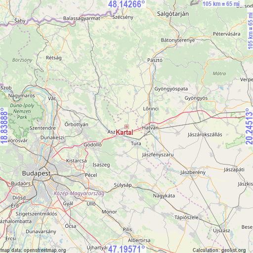
Kartal GPS coordinates[2]
47° 40' 16.788" North, 19° 32' 31.2" East
| Map corner | latitude | longitude |
|---|---|---|
| Upper-left | 48.14266°, | 18.83888° |
| Center: | 47.67133°, | 19.542° |
| Lower-right: | 47.19571°, | 20.24513° |
| Map W x H: | 105.3×105.3 km | = 65.4×65.4mi |
| max Lat: | 48.46667° ⇑31.7% North |
| Kartal: | 47.67133° |
| min Lat: | ⇓68.3% South 45.79108° |
| min Long | Kartal | max Long |
| 16.27358° | 19.542° | 22.68096° |
| W 51.1%⇐ | ⇒48.9% E |
Elevation
Elevation of Kartal is 155 m = 509 ft, and this is 25.3 m = 83 ft above average elevation for this country.
| Max E: |
444 m = 1457 ft | 20.9% |
| Kartal | 155 m 509 ft | |
| Avg. | 129.7 m = 426 ft | |
Min E: |
71 m = 233 ft | 79.1% |
See also: Hungary elevation on elevation.city.
Geographical zone
Kartal is located in North temperate zone (between Tropic of Cancer and the Arctic Circle). Distance of this North polar circle is 2100.6 km =1305.3 mi to North.| Distance of | km | miles | from Kartal |
|---|---|---|---|
| North Pole | 4706.5 | 2924.5 | to North |
| Arctic Circle | 2100.6 | 1305.3 | to North |
| Tropic Cancer | 2694.6 | 1674.3 | to South |
| Equator | 5300.6 | 3293.6 | to South |


Nearby cities:
15 places around Kartal: (largest is in red/bold)
• Aszód
5.2 km =3.2 mi,  245°
245°
• Bag
6.1 km =3.8 mi,  226°
226°
• Boldog
13.4 km =8.3 mi,  124°
124°
• Domony
8.4 km =5.2 mi,  257°
257°
• Galgahévíz
6.4 km =4 mi,  163°
163°
• Galgamácsa
11.9 km =7.4 mi,  283°
283°
• Hatvan
10.6 km =6.6 mi,  92°
92°
• Heréd
7.9 km =4.9 mi,  60°
60°
• Héhalom
12.5 km =7.8 mi,  14°
14°
• Hévízgyörk
4.6 km =2.9 mi,  204°
204°
• Iklad
8 km =5 mi,  265°
265°
• Lőrinci
12.3 km =7.6 mi, 56°
• Tura
8.3 km =5.2 mi,  146°
146°
• Valkó
12.1 km =7.5 mi,  190°
190°
• Vácszentlászló
10.8 km =6.7 mi,  181°
181°
Sources, notices
• [Note1] Compared only with cities in Hungary existing in our database
• [Src1] Map data: © OpenStreetMap contributors (CC-BY-SA)
• [Src2] Other city data from geonames.org with taken over terms of usage.
• [Src3] Geographical zone / Annual Mean Temperature by Robert A. Rohde @ Wikipedia
