Bőny geodata
Bőny (Győr-Moson-Sopron) is a populated place; located in Hungary in Europe/Budapest (GMT+2) time zone. With population of 2,225 people, there are 700 cities with bigger population in this country. Compared to other cities in Hungary, 66.8% of cities are located further ↓South; 87.7% of cities are located further →East and 59.6% of cities have lower elevation than Bőny. Note1


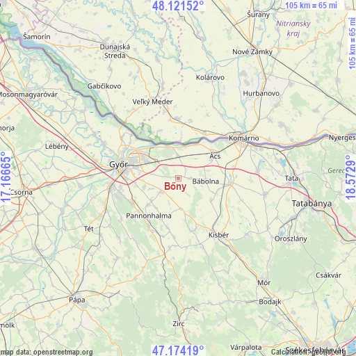
Bőny GPS coordinates[2]
47° 39' 0" North, 17° 52' 11.172" East
| Map corner | latitude | longitude |
|---|---|---|
| Upper-left | 48.12152°, | 17.16665° |
| Center: | 47.65°, | 17.86977° |
| Lower-right: | 47.17419°, | 18.5729° |
| Map W x H: | 105.3×105.3 km | = 65.4×65.4mi |
| max Lat: | 48.46667° ⇑33.2% North |
| Bőny: | 47.65° |
| min Lat: | ⇓66.8% South 45.79108° |
| min Long | Bőny | max Long |
| 16.27358° | 17.86977° | 22.68096° |
| W 12.3%⇐ | ⇒87.7% E |
Elevation
Elevation of Bőny is 125 m = 410 ft, and this is 4.7 m = 15 ft below average elevation for this country.
| Max E: |
444 m = 1457 ft | 40.4% |
| Avg. | 129.7 m = 426 ft | |
| Bőny | 125 m = 410 ft | |
Min E: |
71 m = 233 ft | 59.6% |
See also: Hungary elevation on elevation.city.
Geographical zone
Bőny is located in North temperate zone (between Tropic of Cancer and the Arctic Circle). Distance of this North polar circle is 2103 km =1306.7 mi to North.| Distance of | km | miles | from Bőny |
|---|---|---|---|
| North Pole | 4708.9 | 2926 | to North |
| Arctic Circle | 2103 | 1306.7 | to North |
| Tropic Cancer | 2692.3 | 1672.9 | to South |
| Equator | 5298.2 | 3292.1 | to South |


Nearby cities:
15 places around Bőny: (largest is in red/bold)
• Abda
24.8 km =15.4 mi,  281°
281°
• Bábolna
8.1 km =5 mi,  95°
95°
• Ete
20.3 km =12.6 mi,  130°
130°
• Győr
18 km =11.2 mi, 281°
• Győrszemere
25.4 km =15.8 mi,  244°
244°
• Győrújbarát
17.3 km =10.7 mi,  253°
253°
• Kisbér
20.6 km =12.8 mi,  142°
142°
• Komárom
21.3 km =13.2 mi,  60°
60°
• Mocsa
23.7 km =14.7 mi,  84°
84°
• Nagyigmánd
15.9 km =9.9 mi,  93°
93°
• Nyúl
15.1 km =9.4 mi, 243°
• Pannonhalma
14.1 km =8.8 mi,  217°
217°
• Pér
6.4 km =4 mi,  228°
228°
• Töltéstava
10.5 km =6.5 mi,  255°
255°
• Ács
12.7 km =7.9 mi, 56°
Sources, notices
• [Note1] Compared only with cities in Hungary existing in our database
• [Src1] Map data: © OpenStreetMap contributors (CC-BY-SA)
• [Src2] Other city data from geonames.org with taken over terms of usage.
• [Src3] Geographical zone / Annual Mean Temperature by Robert A. Rohde @ Wikipedia
