Pér geodata
Pér (Győr-Moson-Sopron) is a populated place; located in Hungary in Europe/Budapest (GMT+2) time zone. With population of 2,372 people, there are 646 cities with bigger population in this country. Compared to other cities in Hungary, 63.8% of cities are located further ↓South; 88.1% of cities are located further →East and 62.1% of cities have lower elevation than Pér. Note1


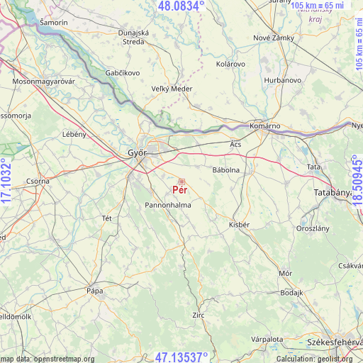
Pér GPS coordinates[2]
47° 36' 41.508" North, 17° 48' 22.752" East
| Map corner | latitude | longitude |
|---|---|---|
| Upper-left | 48.0834°, | 17.1032° |
| Center: | 47.61153°, | 17.80632° |
| Lower-right: | 47.13537°, | 18.50945° |
| Map W x H: | 105.4×105.4 km | = 65.5×65.5mi |
| max Lat: | 48.46667° ⇑36.2% North |
| Pér: | 47.61153° |
| min Lat: | ⇓63.8% South 45.79108° |
| min Long | Pér | max Long |
| 16.27358° | 17.80632° | 22.68096° |
| W 11.9%⇐ | ⇒88.1% E |
Elevation
Elevation of Pér is 128 m = 420 ft, and this is 1.7 m = 6 ft below average elevation for this country.
| Max E: |
444 m = 1457 ft | 37.9% |
| Avg. | 129.7 m = 426 ft | |
| Pér | 128 m = 420 ft | |
Min E: |
71 m = 233 ft | 62.1% |
See also: Hungary elevation on elevation.city.
Geographical zone
Pér is located in North temperate zone (between Tropic of Cancer and the Arctic Circle). Distance of this North polar circle is 2107.3 km =1309.4 mi to North.| Distance of | km | miles | from Pér |
|---|---|---|---|
| North Pole | 4713.2 | 2928.6 | to North |
| Arctic Circle | 2107.3 | 1309.4 | to North |
| Tropic Cancer | 2688 | 1670.2 | to South |
| Equator | 5293.9 | 3289.5 | to South |


Nearby cities:
15 places around Pér: (largest is in red/bold)
• Abda
21.7 km =13.5 mi,  295°
295°
• Bábolna
13.3 km =8.3 mi,  74°
74°
• Bőny
6.4 km =4 mi,  48°
48°
• Ete
22.1 km =13.7 mi,  113°
113°
• Győr
15.1 km =9.4 mi, 301°
• Győrszemere
19.4 km =12.1 mi,  250°
250°
• Győrújbarát
11.8 km =7.3 mi,  267°
267°
• Kisbér
21.1 km =13.1 mi,  124°
124°
• Nagyigmánd
20.9 km =13 mi,  80°
80°
• Nyúl
9.1 km =5.7 mi,  255°
255°
• Pannonhalma
7.9 km =4.9 mi,  208°
208°
• Rábapatona
24.6 km =15.3 mi,  275°
275°
• Tét
24.6 km =15.3 mi, 245°
• Töltéstava
5.7 km =3.5 mi,  286°
286°
• Ács
19 km =11.8 mi, 53°
Sources, notices
• [Note1] Compared only with cities in Hungary existing in our database
• [Src1] Map data: © OpenStreetMap contributors (CC-BY-SA)
• [Src2] Other city data from geonames.org with taken over terms of usage.
• [Src3] Geographical zone / Annual Mean Temperature by Robert A. Rohde @ Wikipedia
