Fót geodata
Fót (Pest) is a populated place; located in Hungary in Europe/Budapest (GMT+2) time zone. With population of 16,770 people, there are 104 cities with bigger population in this country. Compared to other cities in Hungary, 64.5% of cities are located further ↓South; 56.9% of cities are located further →East and 74% of cities have lower elevation than Fót. Note1


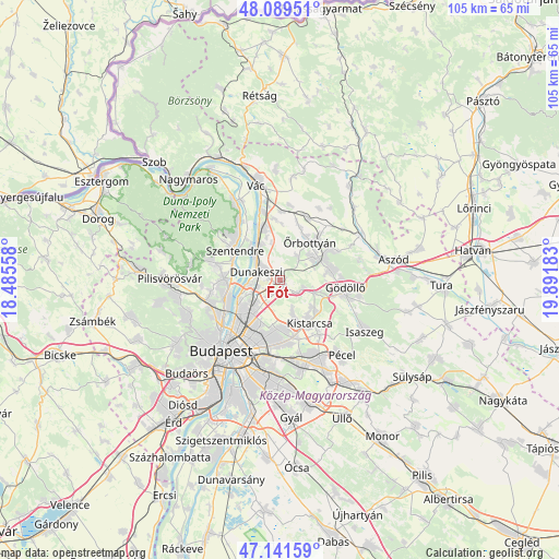
Fót GPS coordinates[2]
47° 37' 3.72" North, 19° 11' 19.32" East
| Map corner | latitude | longitude |
|---|---|---|
| Upper-left | 48.08951°, | 18.48558° |
| Center: | 47.6177°, | 19.1887° |
| Lower-right: | 47.14159°, | 19.89183° |
| Map W x H: | 105.4×105.4 km | = 65.5×65.5mi |
| max Lat: | 48.46667° ⇑35.5% North |
| Fót: | 47.6177° |
| min Lat: | ⇓64.5% South 45.79108° |
| min Long | Fót | max Long |
| 16.27358° | 19.1887° | 22.68096° |
| W 43.1%⇐ | ⇒56.9% E |
Elevation
Elevation of Fót is 145 m = 476 ft, and this is 15.3 m = 50 ft above average elevation for this country.
| Max E: |
444 m = 1457 ft | 26% |
| Fót | 145 m 476 ft | |
| Avg. | 129.7 m = 426 ft | |
Min E: |
71 m = 233 ft | 74% |
See also: Hungary elevation on elevation.city.
Geographical zone
Fót is located in North temperate zone (between Tropic of Cancer and the Arctic Circle). Distance of this North polar circle is 2106.6 km =1309 mi to North.| Distance of | km | miles | from Fót |
|---|---|---|---|
| North Pole | 4712.5 | 2928.2 | to North |
| Arctic Circle | 2106.6 | 1309 | to North |
| Tropic Cancer | 2688.7 | 1670.7 | to South |
| Equator | 5294.6 | 3289.9 | to South |


Nearby cities:
15 places around Fót: (largest is in red/bold)
• Budakalász
10.4 km =6.5 mi,  269°
269°
• Budapest IV. kerület
9.7 km =6 mi,  230°
230°
• Budapest XV. kerület
8.2 km =5.1 mi,  221°
221°
• Budapest XVI. kerület
11.5 km =7.1 mi,  186°
186°
• Csömör
8.2 km =5.1 mi,  156°
156°
• Dunakeszi
4.3 km =2.7 mi,  299°
299°
• Erdőkertes
10.8 km =6.7 mi,  55°
55°
• Göd
8.4 km =5.2 mi,  330°
330°
• Kerepes
9.5 km =5.9 mi,  132°
132°
• Kistarcsa
9.6 km =6 mi,  144°
144°
• Mogyoród
4.5 km =2.8 mi,  119°
119°
• Szada
9.7 km =6 mi,  79°
79°
• Szentendre
10.2 km =6.3 mi, 304°
• Veresegyház
8.6 km =5.3 mi,  68°
68°
• Őrbottyán
10.4 km =6.5 mi,  42°
42°
Sources, notices
• [Note1] Compared only with cities in Hungary existing in our database
• [Src1] Map data: © OpenStreetMap contributors (CC-BY-SA)
• [Src2] Other city data from geonames.org with taken over terms of usage.
• [Src3] Geographical zone / Annual Mean Temperature by Robert A. Rohde @ Wikipedia
