Dunakeszi geodata
Dunakeszi (Pest) is a seat of a second-order administrative division; located in Hungary in Europe/Budapest (GMT+2) time zone. With population of 30,246 people, there are 60 cities with bigger population in this country. Compared to other cities in Hungary, 65.8% of cities are located further ↓South; 58.6% of cities are located further →East and 63% of cities have lower elevation than Dunakeszi. Note1


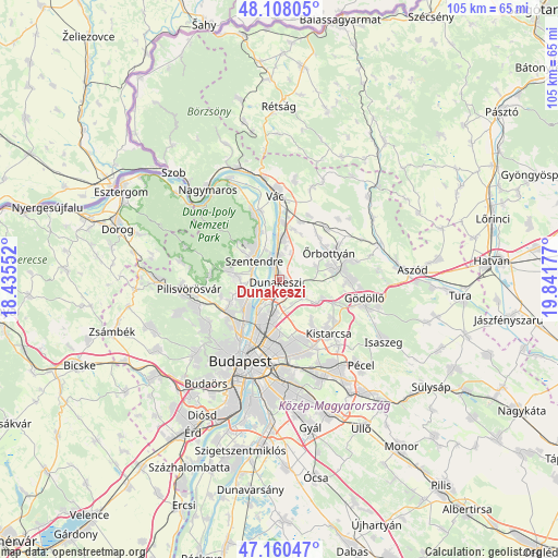
Dunakeszi GPS coordinates[2]
47° 38' 11.076" North, 19° 8' 19.104" East
| Map corner | latitude | longitude |
|---|---|---|
| Upper-left | 48.10805°, | 18.43552° |
| Center: | 47.63641°, | 19.13864° |
| Lower-right: | 47.16047°, | 19.84177° |
| Map W x H: | 105.4×105.4 km | = 65.5×65.5mi |
| max Lat: | 48.46667° ⇑34.2% North |
| Dunakeszi: | 47.63641° |
| min Lat: | ⇓65.8% South 45.79108° |
| min Long | Dunakeszi | max Long |
| 16.27358° | 19.13864° | 22.68096° |
| W 41.4%⇐ | ⇒58.6% E |
Elevation
Elevation of Dunakeszi is 129 m = 423 ft, and this is 0.69999999999999 m = 2 ft below average elevation for this country.
| Max E: |
444 m = 1457 ft | 37% |
| Avg. | 129.7 m = 426 ft | |
| Dunakeszi | 129 m = 423 ft | |
Min E: |
71 m = 233 ft | 63% |
See also: Hungary elevation on elevation.city.
Geographical zone
Dunakeszi is located in North temperate zone (between Tropic of Cancer and the Arctic Circle). Distance of this North polar circle is 2104.5 km =1307.7 mi to North.| Distance of | km | miles | from Dunakeszi |
|---|---|---|---|
| North Pole | 4710.4 | 2926.9 | to North |
| Arctic Circle | 2104.5 | 1307.7 | to North |
| Tropic Cancer | 2690.8 | 1672 | to South |
| Equator | 5296.7 | 3291.2 | to South |


Nearby cities:
15 places around Dunakeszi: (largest is in red/bold)
• Budakalász
7 km =4.3 mi,  251°
251°
• Budapest IV. kerület
9.1 km =5.7 mi,  204°
204°
• Budapest XV. kerület
8.4 km =5.2 mi,  191°
191°
• Fót
4.3 km =2.7 mi,  119°
119°
• Göd
5.2 km =3.2 mi,  356°
356°
• Leányfalu
9.9 km =6.2 mi,  336°
336°
• Mogyoród
8.8 km =5.5 mi, 119°
• Nagykovácsi
9.3 km =5.8 mi,  279°
279°
• Pilisborosjenő
11.4 km =7.1 mi, 253°
• Pomáz
8.3 km =5.2 mi,  274°
274°
• Szentendre
6 km =3.7 mi,  307°
307°
• Sződ
10.1 km =6.3 mi,  13°
13°
• Sződliget
10.7 km =6.6 mi,  3°
3°
• Veresegyház
11.8 km =7.3 mi,  84°
84°
• Üröm
10.2 km =6.3 mi,  244°
244°
Sources, notices
• [Note1] Compared only with cities in Hungary existing in our database
• [Src1] Map data: © OpenStreetMap contributors (CC-BY-SA)
• [Src2] Other city data from geonames.org with taken over terms of usage.
• [Src3] Geographical zone / Annual Mean Temperature by Robert A. Rohde @ Wikipedia
