Fertőrákos geodata
Fertőrákos (Győr-Moson-Sopron) is a populated place; located in Hungary in Europe/Budapest (GMT+2) time zone. With population of 2,179 people, there are 718 cities with bigger population in this country. Compared to other cities in Hungary, 71.9% of cities are located further ↓South; 98.9% of cities are located further →East and 76.6% of cities have lower elevation than Fertőrákos. Note1


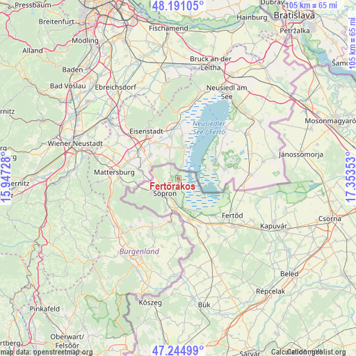
Fertőrákos GPS coordinates[2]
47° 43' 12.612" North, 16° 39' 1.44" East
| Map corner | latitude | longitude |
|---|---|---|
| Upper-left | 48.19105°, | 15.94728° |
| Center: | 47.72017°, | 16.6504° |
| Lower-right: | 47.24499°, | 17.35353° |
| Map W x H: | 105.2×105.2 km | = 65.4×65.4mi |
| max Lat: | 48.46667° ⇑28.1% North |
| Fertőrákos: | 47.72017° |
| min Lat: | ⇓71.9% South 45.79108° |
| min Long | Fertőrákos | max Long |
| 16.27358° | 16.6504° | 22.68096° |
| W 1.1%⇐ | ⇒98.9% E |
Elevation
Elevation of Fertőrákos is 150 m = 492 ft, and this is 20.3 m = 67 ft above average elevation for this country.
| Max E: |
444 m = 1457 ft | 23.4% |
| Fertőrákos | 150 m 492 ft | |
| Avg. | 129.7 m = 426 ft | |
Min E: |
71 m = 233 ft | 76.6% |
See also: Hungary elevation on elevation.city.
Geographical zone
Fertőrákos is located in North temperate zone (between Tropic of Cancer and the Arctic Circle). Distance of this North polar circle is 2095.2 km =1301.9 mi to North.| Distance of | km | miles | from Fertőrákos |
|---|---|---|---|
| North Pole | 4701.1 | 2921.1 | to North |
| Arctic Circle | 2095.2 | 1301.9 | to North |
| Tropic Cancer | 2700.1 | 1677.8 | to South |
| Equator | 5306 | 3297 | to South |


Nearby cities:
15 places around Fertőrákos: (largest is in red/bold)
• Beled
43.6 km =27.1 mi,  130°
130°
• Bük
38 km =23.6 mi,  168°
168°
• Csepreg
35.8 km =22.2 mi, 172°
• Farád
43.1 km =26.8 mi,  107°
107°
• Fertőd
19.8 km =12.3 mi,  123°
123°
• Fertőszentmiklós
22.2 km =13.8 mi, 130°
• Jánossomorja
37 km =23 mi,  78°
78°
• Kapuvár
31.7 km =19.7 mi, 116°
• Kisfalud
39.3 km =24.4 mi, 122°
• Kőszeg
37.7 km =23.4 mi,  192°
192°
• Mihályi
40.5 km =25.2 mi, 124°
• Nagycenk
13.3 km =8.3 mi,  164°
164°
• Répcelak
43.2 km =26.8 mi,  140°
140°
• Sopron
5.9 km =3.7 mi,  228°
228°
• Ágfalva
10.6 km =6.6 mi,  251°
251°
Sources, notices
• [Note1] Compared only with cities in Hungary existing in our database
• [Src1] Map data: © OpenStreetMap contributors (CC-BY-SA)
• [Src2] Other city data from geonames.org with taken over terms of usage.
• [Src3] Geographical zone / Annual Mean Temperature by Robert A. Rohde @ Wikipedia
