Kőszeg geodata
Kőszeg (Vas) is a seat of a second-order administrative division; located in Hungary in Europe/Budapest (GMT+2) time zone. With population of 11,500 people, there are 144 cities with bigger population in this country. Compared to other cities in Hungary, 51.6% of cities are located further ↑North; 99.7% of cities are located further →East and 98.2% of cities have lower elevation than Kőszeg. Note1


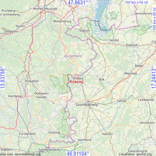
Kőszeg GPS coordinates[2]
47° 23' 21.192" North, 16° 32' 27.6" East
| Map corner | latitude | longitude |
|---|---|---|
| Upper-left | 47.8631°, | 15.83788° |
| Center: | 47.38922°, | 16.541° |
| Lower-right: | 46.91104°, | 17.24413° |
| Map W x H: | 105.9×105.9 km | = 65.8×65.8mi |
| max Lat: | 48.46667° ⇑51.6% North |
| Kőszeg: | 47.38922° |
| min Lat: | ⇓48.4% South 45.79108° |
| min Long | Kőszeg | max Long |
| 16.27358° | 16.541° | 22.68096° |
| W 0.3%⇐ | ⇒99.7% E |
Elevation
Elevation of Kőszeg is 277 m = 909 ft, and this is 147.3 m = 483 ft above average elevation for this country.
| Max E: |
444 m = 1457 ft | 1.8% |
| Kőszeg | 277 m 909 ft | |
| Avg. | 129.7 m = 426 ft | |
Min E: |
71 m = 233 ft | 98.2% |
See also: Hungary elevation on elevation.city.
Geographical zone
Kőszeg is located in North temperate zone (between Tropic of Cancer and the Arctic Circle). Distance of this North polar circle is 2132 km =1324.8 mi to North.| Distance of | km | miles | from Kőszeg |
|---|---|---|---|
| North Pole | 4737.9 | 2944 | to North |
| Arctic Circle | 2132 | 1324.8 | to North |
| Tropic Cancer | 2663.3 | 1654.9 | to South |
| Equator | 5269.2 | 3274.1 | to South |


Nearby cities:
15 places around Kőszeg: (largest is in red/bold)
• Bük
15.8 km =9.8 mi,  91°
91°
• Csepreg
12.7 km =7.9 mi,  84°
84°
• Fertőd
35.8 km =22.2 mi,  43°
43°
• Fertőrákos
37.7 km =23.4 mi,  12°
12°
• Fertőszentmiklós
33.6 km =20.9 mi,  48°
48°
• Gencsapáti
12.3 km =7.6 mi,  160°
160°
• Ják
27.6 km =17.1 mi,  173°
173°
• Nagycenk
26.6 km =16.5 mi,  26°
26°
• Répcelak
36.1 km =22.4 mi, 84°
• Sopron
33.1 km =20.6 mi, 6°
• Szombathely
18.6 km =11.6 mi, 160°
• Sárvár
33.3 km =20.7 mi,  116°
116°
• Táplánszentkereszt
24.6 km =15.3 mi,  151°
151°
• Vép
22.3 km =13.9 mi,  142°
142°
• Ágfalva
33.5 km =20.8 mi,  356°
356°
Sources, notices
• [Note1] Compared only with cities in Hungary existing in our database
• [Src1] Map data: © OpenStreetMap contributors (CC-BY-SA)
• [Src2] Other city data from geonames.org with taken over terms of usage.
• [Src3] Geographical zone / Annual Mean Temperature by Robert A. Rohde @ Wikipedia
