Bük geodata
Bük (Vas) is a populated place; located in Hungary in Europe/Budapest (GMT+2) time zone. With population of 3,174 people, there are 464 cities with bigger population in this country. Compared to other cities in Hungary, 51.9% of cities are located further ↑North; 98.2% of cities are located further →East and 86.8% of cities have lower elevation than Bük. Note1


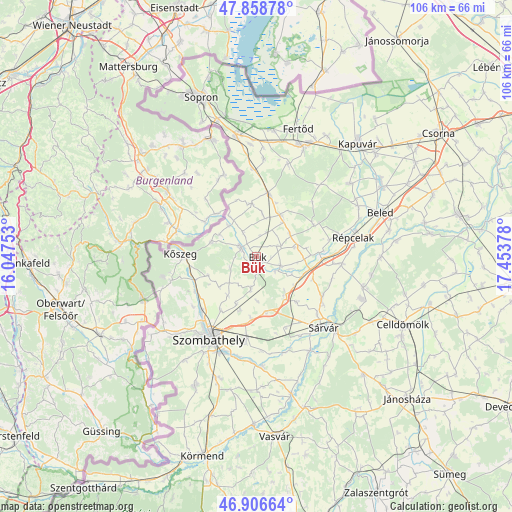
Bük GPS coordinates[2]
47° 23' 5.496" North, 16° 45' 2.34" East
| Map corner | latitude | longitude |
|---|---|---|
| Upper-left | 47.85878°, | 16.04753° |
| Center: | 47.38486°, | 16.75065° |
| Lower-right: | 46.90664°, | 17.45378° |
| Map W x H: | 105.9×105.9 km | = 65.8×65.8mi |
| max Lat: | 48.46667° ⇑51.9% North |
| Bük: | 47.38486° |
| min Lat: | ⇓48.1% South 45.79108° |
| min Long | Bük | max Long |
| 16.27358° | 16.75065° | 22.68096° |
| W 1.8%⇐ | ⇒98.2% E |
Elevation
Elevation of Bük is 178 m = 584 ft, and this is 48.3 m = 158 ft above average elevation for this country.
| Max E: |
444 m = 1457 ft | 13.2% |
| Bük | 178 m 584 ft | |
| Avg. | 129.7 m = 426 ft | |
Min E: |
71 m = 233 ft | 86.8% |
See also: Hungary elevation on elevation.city.
Geographical zone
Bük is located in North temperate zone (between Tropic of Cancer and the Arctic Circle). Distance of this North polar circle is 2132.5 km =1325.1 mi to North.| Distance of | km | miles | from Bük |
|---|---|---|---|
| North Pole | 4738.4 | 2944.3 | to North |
| Arctic Circle | 2132.5 | 1325.1 | to North |
| Tropic Cancer | 2662.8 | 1654.6 | to South |
| Equator | 5268.7 | 3273.8 | to South |


Nearby cities:
15 places around Bük: (largest is in red/bold)
• Beled
27.3 km =17 mi,  70°
70°
• Csepreg
3.6 km =2.2 mi,  299°
299°
• Fertőd
27.8 km =17.3 mi,  18°
18°
• Fertőszentmiklós
24.6 km =15.3 mi, 22°
• Gencsapáti
16.1 km =10 mi,  226°
226°
• Ják
29.8 km =18.5 mi,  205°
205°
• Kisfalud
30.1 km =18.7 mi,  58°
58°
• Kőszeg
15.8 km =9.8 mi,  271°
271°
• Mihályi
29.6 km =18.4 mi, 61°
• Nagycenk
24.7 km =15.3 mi,  350°
350°
• Répcelak
20.5 km =12.7 mi,  78°
78°
• Szombathely
19.7 km =12.2 mi, 209°
• Sárvár
20.1 km =12.5 mi,  136°
136°
• Táplánszentkereszt
21.5 km =13.4 mi,  191°
191°
• Vép
17.3 km =10.7 mi, 187°
Sources, notices
• [Note1] Compared only with cities in Hungary existing in our database
• [Src1] Map data: © OpenStreetMap contributors (CC-BY-SA)
• [Src2] Other city data from geonames.org with taken over terms of usage.
• [Src3] Geographical zone / Annual Mean Temperature by Robert A. Rohde @ Wikipedia
