Ják geodata
Ják (Vas) is a populated place; located in Hungary in Europe/Budapest (GMT+2) time zone. With population of 2,310 people, there are 666 cities with bigger population in this country. Compared to other cities in Hungary, 63.8% of cities are located further ↑North; 99.6% of cities are located further →East and 93% of cities have lower elevation than Ják. Note1


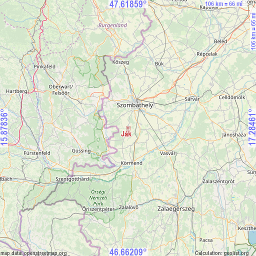
Ják GPS coordinates[2]
47° 8' 32.964" North, 16° 34' 53.328" East
| Map corner | latitude | longitude |
|---|---|---|
| Upper-left | 47.61859°, | 15.87836° |
| Center: | 47.14249°, | 16.58148° |
| Lower-right: | 46.66209°, | 17.28461° |
| Map W x H: | 106.4×106.4 km | = 66.1×66.1mi |
| max Lat: | 48.46667° ⇑63.8% North |
| Ják: | 47.14249° |
| min Lat: | ⇓36.2% South 45.79108° |
| min Long | Ják | max Long |
| 16.27358° | 16.58148° | 22.68096° |
| W 0.4%⇐ | ⇒99.6% E |
Elevation
Elevation of Ják is 206 m = 676 ft, and this is 76.3 m = 250 ft above average elevation for this country.
| Max E: |
444 m = 1457 ft | 7% |
| Ják | 206 m 676 ft | |
| Avg. | 129.7 m = 426 ft | |
Min E: |
71 m = 233 ft | 93% |
See also: Hungary elevation on elevation.city.
Geographical zone
Ják is located in North temperate zone (between Tropic of Cancer and the Arctic Circle). Distance of this North polar circle is 2159.4 km =1341.8 mi to North.| Distance of | km | miles | from Ják |
|---|---|---|---|
| North Pole | 4765.3 | 2961 | to North |
| Arctic Circle | 2159.4 | 1341.8 | to North |
| Tropic Cancer | 2635.8 | 1637.8 | to South |
| Equator | 5241.8 | 3257.1 | to South |


Nearby cities:
15 places around Ják: (largest is in red/bold)
• Alsóújlak
21.7 km =13.5 mi,  108°
108°
• Bük
29.8 km =18.5 mi,  25°
25°
• Csepreg
30.3 km =18.8 mi,  18°
18°
• Gencsapáti
15.9 km =9.9 mi,  3°
3°
• Körmend
14.7 km =9.1 mi,  172°
172°
• Kőszeg
27.6 km =17.1 mi,  353°
353°
• Szentgotthárd
31.5 km =19.6 mi,  227°
227°
• Szombathely
10.3 km =6.4 mi, 17°
• Sárvár
29.5 km =18.3 mi,  65°
65°
• Táplánszentkereszt
10.4 km =6.5 mi,  56°
56°
• Türje
43.6 km =27.1 mi, 113°
• Vasvár
19.5 km =12.1 mi,  122°
122°
• Vép
14.5 km =9 mi,  47°
47°
• Zalaegerszeg
39.1 km =24.3 mi,  149°
149°
• Zalalövő
32.7 km =20.3 mi,  179°
179°
Sources, notices
• [Note1] Compared only with cities in Hungary existing in our database
• [Src1] Map data: © OpenStreetMap contributors (CC-BY-SA)
• [Src2] Other city data from geonames.org with taken over terms of usage.
• [Src3] Geographical zone / Annual Mean Temperature by Robert A. Rohde @ Wikipedia
