Herend geodata
Herend (Veszprém) is a populated place; located in Hungary in Europe/Budapest (GMT+2) time zone. With population of 3,385 people, there are 430 cities with bigger population in this country. Compared to other cities in Hungary, 64.1% of cities are located further ↑North; 88.8% of cities are located further →East and 99.2% of cities have lower elevation than Herend. Note1


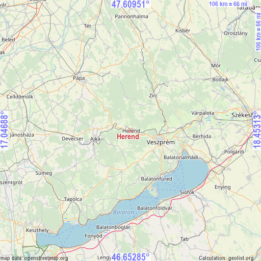
Herend GPS coordinates[2]
47° 7' 59.988" North, 17° 45' 0" East
| Map corner | latitude | longitude |
|---|---|---|
| Upper-left | 47.60951°, | 17.04688° |
| Center: | 47.13333°, | 17.75° |
| Lower-right: | 46.65285°, | 18.45313° |
| Map W x H: | 106.4×106.4 km | = 66.1×66.1mi |
| max Lat: | 48.46667° ⇑64.1% North |
| Herend: | 47.13333° |
| min Lat: | ⇓35.9% South 45.79108° |
| min Long | Herend | max Long |
| 16.27358° | 17.75° | 22.68096° |
| W 11.2%⇐ | ⇒88.8% E |
Elevation
Elevation of Herend is 316 m = 1037 ft, and this is 186.3 m = 611 ft above average elevation for this country.
| Max E: |
444 m = 1457 ft | 0.8% |
| Herend | 316 m 1037 ft | |
| Avg. | 129.7 m = 426 ft | |
Min E: |
71 m = 233 ft | 99.2% |
See also: Hungary elevation on elevation.city.
Geographical zone
Herend is located in North temperate zone (between Tropic of Cancer and the Arctic Circle). Distance of this North polar circle is 2160.4 km =1342.4 mi to North.| Distance of | km | miles | from Herend |
|---|---|---|---|
| North Pole | 4766.3 | 2961.6 | to North |
| Arctic Circle | 2160.4 | 1342.4 | to North |
| Tropic Cancer | 2634.8 | 1637.2 | to South |
| Equator | 5240.7 | 3256.4 | to South |


Nearby cities:
15 places around Herend: (largest is in red/bold)
• Ajka
14.9 km =9.3 mi,  256°
256°
• Balatonalmádi
23.2 km =14.4 mi,  118°
118°
• Balatonfüred
21.2 km =13.2 mi,  154°
154°
• Bánd
2.7 km =1.7 mi, 117°
• Csetény
27.5 km =17.1 mi,  41°
41°
• Csopak
21.5 km =13.4 mi,  143°
143°
• Devecser
23.8 km =14.8 mi, 261°
• Hajmáskér
20.4 km =12.7 mi,  86°
86°
• Litér
19.6 km =12.2 mi,  100°
100°
• Nemesvámos
12.8 km =8 mi,  132°
132°
• Szentkirályszabadja
18.7 km =11.6 mi, 116°
• Tihany
26.6 km =16.5 mi,  156°
156°
• Veszprém
13 km =8.1 mi,  110°
110°
• Zirc
17.2 km =10.7 mi,  32°
32°
• Úrkút
9.7 km =6 mi,  236°
236°
Sources, notices
• [Note1] Compared only with cities in Hungary existing in our database
• [Src1] Map data: © OpenStreetMap contributors (CC-BY-SA)
• [Src2] Other city data from geonames.org with taken over terms of usage.
• [Src3] Geographical zone / Annual Mean Temperature by Robert A. Rohde @ Wikipedia
