Héhalom geodata
Héhalom (Nógrád) is a populated place; located in Hungary in Europe/Budapest (GMT+2) time zone. With population of 1,006 people, there are 871 cities with bigger population in this country. Compared to other cities in Hungary, 75.8% of cities are located further ↓South; 52.1% of cities are located further ←West and 69.8% of cities have lower elevation than Héhalom. Note1


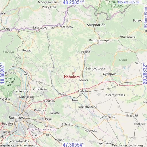
Héhalom GPS coordinates[2]
47° 46' 48.612" North, 19° 35' 6.684" East
| Map corner | latitude | longitude |
|---|---|---|
| Upper-left | 48.25051°, | 18.88207° |
| Center: | 47.78017°, | 19.58519° |
| Lower-right: | 47.30554°, | 20.28832° |
| Map W x H: | 105.1×105.1 km | = 65.3×65.3mi |
| max Lat: | 48.46667° ⇑24.2% North |
| Héhalom: | 47.78017° |
| min Lat: | ⇓75.8% South 45.79108° |
| min Long | Héhalom | max Long |
| 16.27358° | 19.58519° | 22.68096° |
| W 52.1%⇐ | ⇒47.9% E |
Elevation
Elevation of Héhalom is 137 m = 449 ft, and this is 7.3 m = 24 ft above average elevation for this country.
| Max E: |
444 m = 1457 ft | 30.2% |
| Héhalom | 137 m 449 ft | |
| Avg. | 129.7 m = 426 ft | |
Min E: |
71 m = 233 ft | 69.8% |
See also: Hungary elevation on elevation.city.
Geographical zone
Héhalom is located in North temperate zone (between Tropic of Cancer and the Arctic Circle). Distance of this North polar circle is 2088.5 km =1297.7 mi to North.| Distance of | km | miles | from Héhalom |
|---|---|---|---|
| North Pole | 4694.4 | 2917 | to North |
| Arctic Circle | 2088.5 | 1297.7 | to North |
| Tropic Cancer | 2706.7 | 1681.9 | to South |
| Equator | 5312.7 | 3301.2 | to South |


Nearby cities:
15 places around Héhalom: (largest is in red/bold)
• Acsa
14.8 km =9.2 mi,  276°
276°
• Apc
8.3 km =5.2 mi,  79°
79°
• Buják
11.9 km =7.4 mi,  344°
344°
• Ecséd
14.6 km =9.1 mi,  111°
111°
• Gyöngyöspata
15.7 km =9.8 mi, 75°
• Hatvan
14.6 km =9.1 mi,  149°
149°
• Heréd
9 km =5.6 mi,  156°
156°
• Jobbágyi
9 km =5.6 mi,  49°
49°
• Kartal
12.5 km =7.8 mi,  194°
194°
• Lőrinci
8.7 km =5.4 mi,  126°
126°
• Palotás
1.9 km =1.2 mi,  26°
26°
• Petőfibánya
8.7 km =5.4 mi,  97°
97°
• Rózsaszentmárton
11.7 km =7.3 mi,  89°
89°
• Szurdokpüspöki
11.9 km =7.4 mi,  42°
42°
• Zagyvaszántó
6.4 km =4 mi, 93°
Sources, notices
• [Note1] Compared only with cities in Hungary existing in our database
• [Src1] Map data: © OpenStreetMap contributors (CC-BY-SA)
• [Src2] Other city data from geonames.org with taken over terms of usage.
• [Src3] Geographical zone / Annual Mean Temperature by Robert A. Rohde @ Wikipedia
