Rózsaszentmárton geodata
Rózsaszentmárton (Heves) is a populated place; located in Hungary in Europe/Budapest (GMT+2) time zone. With population of 2,028 people, there are 770 cities with bigger population in this country. Compared to other cities in Hungary, 76% of cities are located further ↓South; 55.8% of cities are located further ←West and 86.5% of cities have lower elevation than Rózsaszentmárton. Note1


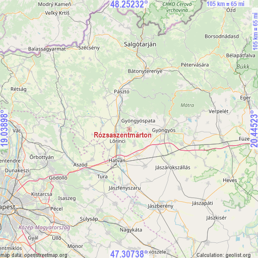
Rózsaszentmárton GPS coordinates[2]
47° 46' 55.2" North, 19° 44' 31.56" East
| Map corner | latitude | longitude |
|---|---|---|
| Upper-left | 48.25232°, | 19.03898° |
| Center: | 47.782°, | 19.7421° |
| Lower-right: | 47.30738°, | 20.44523° |
| Map W x H: | 105.1×105.1 km | = 65.3×65.3mi |
| max Lat: | 48.46667° ⇑24% North |
| Rózsaszentmárton: | 47.782° |
| min Lat: | ⇓76% South 45.79108° |
| min Long | Rózsaszentmár | max Long |
| 16.27358° | 19.7421° | 22.68096° |
| W 55.8%⇐ | ⇒44.2% E |
Elevation
Elevation of Rózsaszentmárton is 177 m = 581 ft, and this is 47.3 m = 155 ft above average elevation for this country.
| Max E: |
444 m = 1457 ft | 13.5% |
| Rózsaszentmárton | 177 m 581 ft | |
| Avg. | 129.7 m = 426 ft | |
Min E: |
71 m = 233 ft | 86.5% |
See also: Hungary elevation on elevation.city.
Geographical zone
Rózsaszentmárton is located in North temperate zone (between Tropic of Cancer and the Arctic Circle). Distance of this North polar circle is 2088.3 km =1297.6 mi to North.| Distance of | km | miles | from Rózsaszentmárton |
|---|---|---|---|
| North Pole | 4694.2 | 2916.8 | to North |
| Arctic Circle | 2088.3 | 1297.6 | to North |
| Tropic Cancer | 2706.9 | 1682 | to South |
| Equator | 5312.9 | 3301.3 | to South |


Nearby cities:
15 places around Rózsaszentmárton: (largest is in red/bold)
• Apc
3.8 km =2.4 mi,  290°
290°
• Ecséd
5.8 km =3.6 mi,  161°
161°
• Gyöngyöspata
5.1 km =3.2 mi,  43°
43°
• Gyöngyöstarján
10 km =6.2 mi,  69°
69°
• Hatvan
13.6 km =8.5 mi,  198°
198°
• Heréd
11.7 km =7.3 mi,  224°
224°
• Hort
10.7 km =6.6 mi, 160°
• Héhalom
11.7 km =7.3 mi,  269°
269°
• Jobbágyi
7.4 km =4.6 mi,  319°
319°
• Lőrinci
7.2 km =4.5 mi, 221°
• Nagyréde
8.1 km =5 mi,  103°
103°
• Palotás
11 km =6.8 mi,  277°
277°
• Petőfibánya
3.4 km =2.1 mi,  246°
246°
• Szurdokpüspöki
9.4 km =5.8 mi,  336°
336°
• Zagyvaszántó
5.3 km =3.3 mi,  264°
264°
Sources, notices
• [Note1] Compared only with cities in Hungary existing in our database
• [Src1] Map data: © OpenStreetMap contributors (CC-BY-SA)
• [Src2] Other city data from geonames.org with taken over terms of usage.
• [Src3] Geographical zone / Annual Mean Temperature by Robert A. Rohde @ Wikipedia
