Gyöngyöspata geodata
Gyöngyöspata (Heves) is a populated place; located in Hungary in Europe/Budapest (GMT+2) time zone. With population of 2,724 people, there are 562 cities with bigger population in this country. Compared to other cities in Hungary, 78.2% of cities are located further ↓South; 57.2% of cities are located further ←West and 92.4% of cities have lower elevation than Gyöngyöspata. Note1


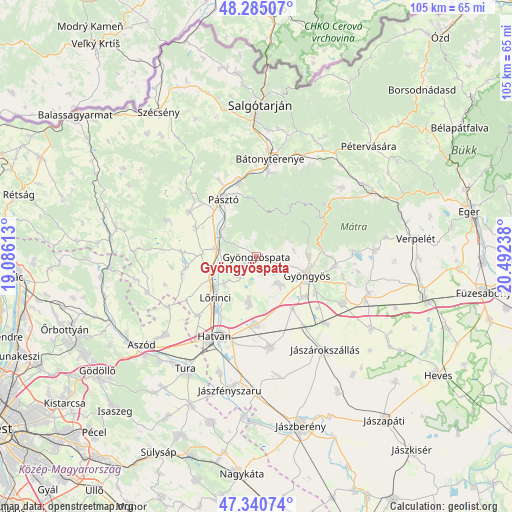
Gyöngyöspata GPS coordinates[2]
47° 48' 54.18" North, 19° 47' 21.3" East
| Map corner | latitude | longitude |
|---|---|---|
| Upper-left | 48.28507°, | 19.08613° |
| Center: | 47.81505°, | 19.78925° |
| Lower-right: | 47.34074°, | 20.49238° |
| Map W x H: | 105×105 km | = 65.2×65.2mi |
| max Lat: | 48.46667° ⇑21.8% North |
| Gyöngyöspata: | 47.81505° |
| min Lat: | ⇓78.2% South 45.79108° |
| min Long | Gyöngyöspata | max Long |
| 16.27358° | 19.78925° | 22.68096° |
| W 57.2%⇐ | ⇒42.8% E |
Elevation
Elevation of Gyöngyöspata is 201 m = 659 ft, and this is 71.3 m = 234 ft above average elevation for this country.
| Max E: |
444 m = 1457 ft | 7.6% |
| Gyöngyöspata | 201 m 659 ft | |
| Avg. | 129.7 m = 426 ft | |
Min E: |
71 m = 233 ft | 92.4% |
See also: Hungary elevation on elevation.city.
Geographical zone
Gyöngyöspata is located in North temperate zone (between Tropic of Cancer and the Arctic Circle). Distance of this North polar circle is 2084.6 km =1295.3 mi to North.| Distance of | km | miles | from Gyöngyöspata |
|---|---|---|---|
| North Pole | 4690.5 | 2914.5 | to North |
| Arctic Circle | 2084.6 | 1295.3 | to North |
| Tropic Cancer | 2710.6 | 1684.3 | to South |
| Equator | 5316.5 | 3303.5 | to South |


Nearby cities:
15 places around Gyöngyöspata: (largest is in red/bold)
• Apc
7.5 km =4.7 mi,  251°
251°
• Ecséd
9.3 km =5.8 mi,  190°
190°
• Gyöngyös
11 km =6.8 mi,  109°
109°
• Gyöngyöshalász
13.2 km =8.2 mi,  128°
128°
• Gyöngyössolymos
11 km =6.8 mi,  88°
88°
• Gyöngyöstarján
5.8 km =3.6 mi, 91°
• Hort
13.8 km =8.6 mi,  179°
179°
• Jobbágyi
8.6 km =5.3 mi,  283°
283°
• Lőrinci
12.3 km =7.6 mi,  222°
222°
• Nagyréde
7.1 km =4.4 mi,  141°
141°
• Petőfibánya
8.4 km =5.2 mi,  232°
232°
• Pásztó
13.5 km =8.4 mi,  329°
329°
• Rózsaszentmárton
5.1 km =3.2 mi, 223°
• Szurdokpüspöki
8.8 km =5.5 mi,  304°
304°
• Zagyvaszántó
9.8 km =6.1 mi,  244°
244°
Sources, notices
• [Note1] Compared only with cities in Hungary existing in our database
• [Src1] Map data: © OpenStreetMap contributors (CC-BY-SA)
• [Src2] Other city data from geonames.org with taken over terms of usage.
• [Src3] Geographical zone / Annual Mean Temperature by Robert A. Rohde @ Wikipedia
