Szurdokpüspöki geodata
Szurdokpüspöki (Nógrád) is a populated place; located in Hungary in Europe/Budapest (GMT+2) time zone. With population of 1,947 people, there are 808 cities with bigger population in this country. Compared to other cities in Hungary, 80.6% of cities are located further ↓South; 54.8% of cities are located further ←West and 76.6% of cities have lower elevation than Szurdokpüspöki. Note1


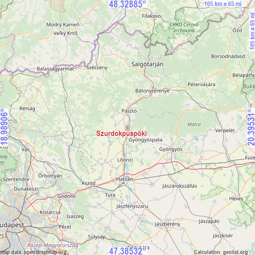
Szurdokpüspöki GPS coordinates[2]
47° 51' 33.228" North, 19° 41' 31.848" East
| Map corner | latitude | longitude |
|---|---|---|
| Upper-left | 48.32885°, | 18.98906° |
| Center: | 47.85923°, | 19.69218° |
| Lower-right: | 47.38532°, | 20.39531° |
| Map W x H: | 104.9×104.9 km | = 65.2×65.2mi |
| max Lat: | 48.46667° ⇑19.4% North |
| Szurdokpüspöki: | 47.85923° |
| min Lat: | ⇓80.6% South 45.79108° |
| min Long | Szurdokpüspök | max Long |
| 16.27358° | 19.69218° | 22.68096° |
| W 54.8%⇐ | ⇒45.2% E |
Elevation
Elevation of Szurdokpüspöki is 150 m = 492 ft, and this is 20.3 m = 67 ft above average elevation for this country.
| Max E: |
444 m = 1457 ft | 23.4% |
| Szurdokpüspöki | 150 m 492 ft | |
| Avg. | 129.7 m = 426 ft | |
Min E: |
71 m = 233 ft | 76.6% |
See also: Hungary elevation on elevation.city.
Geographical zone
Szurdokpüspöki is located in North temperate zone (between Tropic of Cancer and the Arctic Circle). Distance of this North polar circle is 2079.7 km =1292.3 mi to North.| Distance of | km | miles | from Szurdokpüspöki |
|---|---|---|---|
| North Pole | 4685.6 | 2911.5 | to North |
| Arctic Circle | 2079.7 | 1292.3 | to North |
| Tropic Cancer | 2715.5 | 1687.3 | to South |
| Equator | 5321.4 | 3306.6 | to South |


Nearby cities:
15 places around Szurdokpüspöki: (largest is in red/bold)
• Apc
7.2 km =4.5 mi,  178°
178°
• Buják
11.4 km =7.1 mi,  283°
283°
• Ecséd
15.1 km =9.4 mi,  158°
158°
• Gyöngyöspata
8.8 km =5.5 mi,  124°
124°
• Gyöngyöstarján
14 km =8.7 mi,  111°
111°
• Héhalom
11.9 km =7.4 mi,  222°
222°
• Jobbágyi
3.2 km =2 mi,  199°
199°
• Lőrinci
14.1 km =8.8 mi, 184°
• Mátraverebély
14.4 km =8.9 mi,  27°
27°
• Palotás
10.1 km =6.3 mi,  225°
225°
• Petőfibánya
10 km =6.2 mi, 176°
• Pásztó
6.8 km =4.2 mi,  3°
3°
• Rózsaszentmárton
9.4 km =5.8 mi, 156°
• Tar
11.2 km =7 mi,  20°
20°
• Zagyvaszántó
9.3 km =5.8 mi,  189°
189°
Sources, notices
• [Note1] Compared only with cities in Hungary existing in our database
• [Src1] Map data: © OpenStreetMap contributors (CC-BY-SA)
• [Src2] Other city data from geonames.org with taken over terms of usage.
• [Src3] Geographical zone / Annual Mean Temperature by Robert A. Rohde @ Wikipedia
