Mátraterenye geodata
Mátraterenye (Nógrád) is a populated place; located in Hungary in Europe/Budapest (GMT+2) time zone. With population of 1,995 people, there are 790 cities with bigger population in this country. Compared to other cities in Hungary, 88.4% of cities are located further ↓South; 60.5% of cities are located further ←West and 95.5% of cities have lower elevation than Mátraterenye. Note1


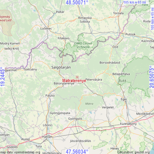
Mátraterenye GPS coordinates[2]
48° 1' 57.612" North, 19° 56' 51.432" East
| Map corner | latitude | longitude |
|---|---|---|
| Upper-left | 48.50071°, | 19.2445° |
| Center: | 48.03267°, | 19.94762° |
| Lower-right: | 47.56034°, | 20.65075° |
| Map W x H: | 104.6×104.6 km | = 65×65mi |
| max Lat: | 48.46667° ⇑11.6% North |
| Mátraterenye: | 48.03267° |
| min Lat: | ⇓88.4% South 45.79108° |
| min Long | Mátraterenye | max Long |
| 16.27358° | 19.94762° | 22.68096° |
| W 60.5%⇐ | ⇒39.5% E |
Elevation
Elevation of Mátraterenye is 228 m = 748 ft, and this is 98.3 m = 323 ft above average elevation for this country.
| Max E: |
444 m = 1457 ft | 4.5% |
| Mátraterenye | 228 m 748 ft | |
| Avg. | 129.7 m = 426 ft | |
Min E: |
71 m = 233 ft | 95.5% |
See also: Hungary elevation on elevation.city.
Geographical zone
Mátraterenye is located in North temperate zone (between Tropic of Cancer and the Arctic Circle). Distance of this North polar circle is 2060.4 km =1280.3 mi to North.| Distance of | km | miles | from Mátraterenye |
|---|---|---|---|
| North Pole | 4666.3 | 2899.5 | to North |
| Arctic Circle | 2060.4 | 1280.3 | to North |
| Tropic Cancer | 2734.8 | 1699.3 | to South |
| Equator | 5340.7 | 3318.6 | to South |


Nearby cities:
15 places around Mátraterenye: (largest is in red/bold)
• Bátonyterenye
10.6 km =6.6 mi,  228°
228°
• Karancslapujtő
20.6 km =12.8 mi,  309°
309°
• Kazár
6.7 km =4.2 mi,  286°
286°
• Mátraderecske
13.7 km =8.5 mi,  132°
132°
• Mátranovák
2.7 km =1.7 mi,  76°
76°
• Mátraverebély
14 km =8.7 mi,  242°
242°
• Parád
13.6 km =8.5 mi,  153°
153°
• Parádsasvár
13.5 km =8.4 mi,  170°
170°
• Pétervására
11.5 km =7.1 mi,  98°
98°
• Recsk
16.7 km =10.4 mi, 131°
• Salgótarján
13 km =8.1 mi,  304°
304°
• Sirok
21.8 km =13.5 mi,  120°
120°
• Somoskőújfalu
17.3 km =10.7 mi,  327°
327°
• Tar
17.4 km =10.8 mi, 239°
• Tarnalelesz
17.6 km =10.9 mi, 83°
Sources, notices
• [Note1] Compared only with cities in Hungary existing in our database
• [Src1] Map data: © OpenStreetMap contributors (CC-BY-SA)
• [Src2] Other city data from geonames.org with taken over terms of usage.
• [Src3] Geographical zone / Annual Mean Temperature by Robert A. Rohde @ Wikipedia
