Adács geodata
Adács (Heves) is a populated place; located in Hungary in Europe/Budapest (GMT+2) time zone. With population of 2,890 people, there are 519 cities with bigger population in this country. Compared to other cities in Hungary, 70.2% of cities are located further ↓South; 61% of cities are located further ←West and 58.1% of cities have higher elevation than Adács. Note1


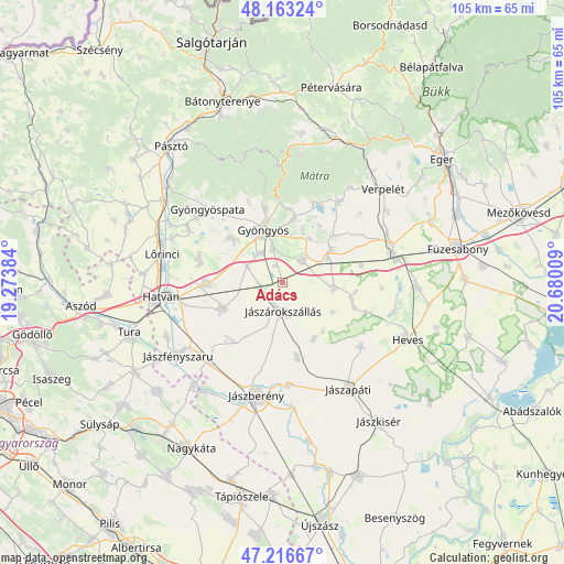
Adács GPS coordinates[2]
47° 41' 31.56" North, 19° 58' 37.056" East
| Map corner | latitude | longitude |
|---|---|---|
| Upper-left | 48.16324°, | 19.27384° |
| Center: | 47.6921°, | 19.97696° |
| Lower-right: | 47.21667°, | 20.68009° |
| Map W x H: | 105.2×105.2 km | = 65.4×65.4mi |
| max Lat: | 48.46667° ⇑29.8% North |
| Adács: | 47.6921° |
| min Lat: | ⇓70.2% South 45.79108° |
| min Long | Adács | max Long |
| 16.27358° | 19.97696° | 22.68096° |
| W 61%⇐ | ⇒39% E |
Elevation
Elevation of Adács is 111 m = 364 ft, and this is 18.7 m = 61 ft below average elevation for this country.
| Max E: |
444 m = 1457 ft | 58.1% |
| Avg. | 129.7 m = 426 ft | |
| Adács | 111 m = 364 ft | |
Min E: |
71 m = 233 ft | 41.9% |
See also: Hungary elevation on elevation.city.
Geographical zone
Adács is located in North temperate zone (between Tropic of Cancer and the Arctic Circle). Distance of this North polar circle is 2098.3 km =1303.8 mi to North.| Distance of | km | miles | from Adács |
|---|---|---|---|
| North Pole | 4704.2 | 2923.1 | to North |
| Arctic Circle | 2098.3 | 1303.8 | to North |
| Tropic Cancer | 2696.9 | 1675.8 | to South |
| Equator | 5302.9 | 3295.1 | to South |


Nearby cities:
15 places around Adács: (largest is in red/bold)
• Abasár
11.8 km =7.3 mi,  9°
9°
• Csány
12.1 km =7.5 mi,  246°
246°
• Domoszló
18.9 km =11.7 mi,  33°
33°
• Ecséd
16.3 km =10.1 mi,  286°
286°
• Gyöngyös
10.7 km =6.6 mi,  340°
340°
• Gyöngyöshalász
6.6 km =4.1 mi,  326°
326°
• Gyöngyössolymos
14.2 km =8.8 mi,  347°
347°
• Gyöngyöstarján
15.8 km =9.8 mi, 328°
• Hort
14 km =8.7 mi,  269°
269°
• Jászdózsa
14.3 km =8.9 mi,  168°
168°
• Jászárokszállás
5.5 km =3.4 mi,  177°
177°
• Karácsond
5.8 km =3.6 mi,  43°
43°
• Nagyréde
12.6 km =7.8 mi,  310°
310°
• Tarnaörs
12.2 km =7.6 mi,  152°
152°
• Vámosgyörk
3.7 km =2.3 mi,  256°
256°
Sources, notices
• [Note1] Compared only with cities in Hungary existing in our database
• [Src1] Map data: © OpenStreetMap contributors (CC-BY-SA)
• [Src2] Other city data from geonames.org with taken over terms of usage.
• [Src3] Geographical zone / Annual Mean Temperature by Robert A. Rohde @ Wikipedia
