Baks geodata
Baks (Csongrád) is a populated place; located in Hungary in Europe/Budapest (GMT+2) time zone. With population of 2,292 people, there are 674 cities with bigger population in this country. Compared to other cities in Hungary, 84.6% of cities are located further ↑North; 64.2% of cities are located further ←West and 98.9% of cities have higher elevation than Baks. Note1


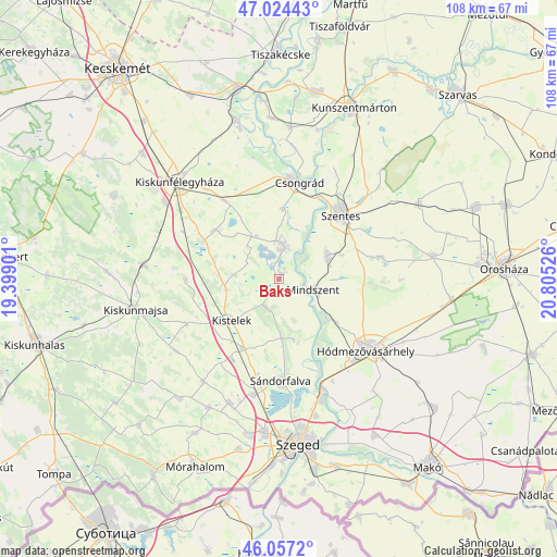
Baks GPS coordinates[2]
46° 32' 34.692" North, 20° 6' 7.668" East
| Map corner | latitude | longitude |
|---|---|---|
| Upper-left | 47.02443°, | 19.39901° |
| Center: | 46.54297°, | 20.10213° |
| Lower-right: | 46.0572°, | 20.80526° |
| Map W x H: | 107.5×107.5 km | = 66.8×66.8mi |
| max Lat: | 48.46667° ⇑84.6% North |
| Baks: | 46.54297° |
| min Lat: | ⇓15.4% South 45.79108° |
| min Long | Baks | max Long |
| 16.27358° | 20.10213° | 22.68096° |
| W 64.2%⇐ | ⇒35.8% E |
Elevation
Elevation of Baks is 80 m = 262 ft, and this is 49.7 m = 163 ft below average elevation for this country.
| Max E: |
444 m = 1457 ft | 98.9% |
| Avg. | 129.7 m = 426 ft | |
| Baks | 80 m = 262 ft | |
Min E: |
71 m = 233 ft | 1.1% |
See also: Hungary elevation on elevation.city.
Geographical zone
Baks is located in North temperate zone (between Tropic of Cancer and the Arctic Circle). Distance of this North polar circle is 2226.1 km =1383.2 mi to North.| Distance of | km | miles | from Baks |
|---|---|---|---|
| North Pole | 4832 | 3002.5 | to North |
| Arctic Circle | 2226.1 | 1383.2 | to North |
| Tropic Cancer | 2569.2 | 1596.4 | to South |
| Equator | 5175.1 | 3215.7 | to South |


Nearby cities:
15 places around Baks: (largest is in red/bold)
• Balástya
15.2 km =9.4 mi,  208°
208°
• Csanytelek
6 km =3.7 mi,  15°
15°
• Csengele
18.2 km =11.3 mi,  269°
269°
• Csongrád
19.2 km =11.9 mi,  9°
9°
• Hódmezővásárhely
22.6 km =14 mi,  128°
128°
• Kistelek
12.2 km =7.6 mi,  230°
230°
• Mindszent
7.1 km =4.4 mi,  107°
107°
• Pusztaszer
8.8 km =5.5 mi,  275°
275°
• Pálmonostora
14.6 km =9.1 mi,  308°
308°
• Szatymaz
22.7 km =14.1 mi,  192°
192°
• Szegvár
10.6 km =6.6 mi,  62°
62°
• Szentes
17.6 km =10.9 mi,  43°
43°
• Sándorfalva
20.2 km =12.6 mi,  180°
180°
• Tömörkény
9.4 km =5.8 mi,  331°
331°
• Ópusztaszer
6.4 km =4 mi, 190°
Sources, notices
• [Note1] Compared only with cities in Hungary existing in our database
• [Src1] Map data: © OpenStreetMap contributors (CC-BY-SA)
• [Src2] Other city data from geonames.org with taken over terms of usage.
• [Src3] Geographical zone / Annual Mean Temperature by Robert A. Rohde @ Wikipedia
