Tömörkény geodata
Tömörkény (Csongrád) is a populated place; located in Hungary in Europe/Budapest (GMT+2) time zone. With population of 1,944 people, there are 810 cities with bigger population in this country. Compared to other cities in Hungary, 82.9% of cities are located further ↑North; 63.1% of cities are located further ←West and 97.3% of cities have higher elevation than Tömörkény. Note1


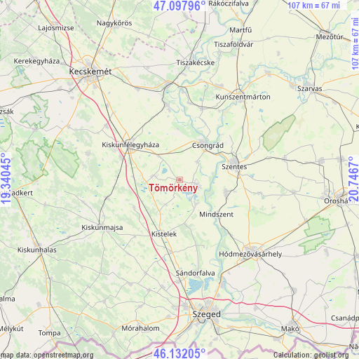
Tömörkény GPS coordinates[2]
46° 37' 1.776" North, 20° 2' 36.852" East
| Map corner | latitude | longitude |
|---|---|---|
| Upper-left | 47.09796°, | 19.34045° |
| Center: | 46.61716°, | 20.04357° |
| Lower-right: | 46.13205°, | 20.7467° |
| Map W x H: | 107.4×107.4 km | = 66.7×66.7mi |
| max Lat: | 48.46667° ⇑82.9% North |
| Tömörkény: | 46.61716° |
| min Lat: | ⇓17.1% South 45.79108° |
| min Long | Tömörkény | max Long |
| 16.27358° | 20.04357° | 22.68096° |
| W 63.1%⇐ | ⇒36.9% E |
Elevation
Elevation of Tömörkény is 82 m = 269 ft, and this is 47.7 m = 156 ft below average elevation for this country.
| Max E: |
444 m = 1457 ft | 97.3% |
| Avg. | 129.7 m = 426 ft | |
| Tömörkény | 82 m = 269 ft | |
Min E: |
71 m = 233 ft | 2.7% |
See also: Hungary elevation on elevation.city.
Geographical zone
Tömörkény is located in North temperate zone (between Tropic of Cancer and the Arctic Circle). Distance of this North polar circle is 2217.8 km =1378.1 mi to North.| Distance of | km | miles | from Tömörkény |
|---|---|---|---|
| North Pole | 4823.7 | 2997.3 | to North |
| Arctic Circle | 2217.8 | 1378.1 | to North |
| Tropic Cancer | 2577.4 | 1601.5 | to South |
| Equator | 5183.3 | 3220.8 | to South |


Nearby cities:
15 places around Tömörkény: (largest is in red/bold)
• Baks
9.4 km =5.8 mi,  151°
151°
• Balástya
21.8 km =13.5 mi,  187°
187°
• Csanytelek
6.6 km =4.1 mi,  111°
111°
• Csengele
16.1 km =10 mi,  238°
238°
• Csongrád
13.1 km =8.1 mi,  35°
35°
• Jászszentlászló
22.3 km =13.9 mi,  255°
255°
• Kiskunfélegyháza
18.5 km =11.5 mi,  304°
304°
• Kistelek
16.8 km =10.4 mi,  196°
196°
• Mindszent
15.3 km =9.5 mi,  132°
132°
• Pusztaszer
8.5 km =5.3 mi,  209°
209°
• Pálmonostora
7.1 km =4.4 mi,  276°
276°
• Szegvár
14.2 km =8.8 mi,  103°
103°
• Szentes
17.2 km =10.7 mi,  74°
74°
• Tiszaalpár
22 km =13.7 mi,  351°
351°
• Ópusztaszer
15 km =9.3 mi,  167°
167°
Sources, notices
• [Note1] Compared only with cities in Hungary existing in our database
• [Src1] Map data: © OpenStreetMap contributors (CC-BY-SA)
• [Src2] Other city data from geonames.org with taken over terms of usage.
• [Src3] Geographical zone / Annual Mean Temperature by Robert A. Rohde @ Wikipedia
