Pálmonostora geodata
Pálmonostora (Bács-Kiskun) is a populated place; located in Hungary in Europe/Budapest (GMT+2) time zone. With population of 2,052 people, there are 759 cities with bigger population in this country. Compared to other cities in Hungary, 82.4% of cities are located further ↑North; 60.6% of cities are located further ←West and 93.3% of cities have higher elevation than Pálmonostora. Note1


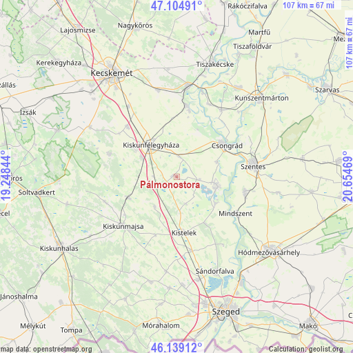
Pálmonostora GPS coordinates[2]
46° 37' 27.012" North, 19° 57' 5.616" East
| Map corner | latitude | longitude |
|---|---|---|
| Upper-left | 47.10491°, | 19.24844° |
| Center: | 46.62417°, | 19.95156° |
| Lower-right: | 46.13912°, | 20.65469° |
| Map W x H: | 107.4×107.4 km | = 66.7×66.7mi |
| max Lat: | 48.46667° ⇑82.4% North |
| Pálmonostora: | 46.62417° |
| min Lat: | ⇓17.6% South 45.79108° |
| min Long | Pálmonostora | max Long |
| 16.27358° | 19.95156° | 22.68096° |
| W 60.6%⇐ | ⇒39.4% E |
Elevation
Elevation of Pálmonostora is 85 m = 279 ft, and this is 44.7 m = 147 ft below average elevation for this country.
| Max E: |
444 m = 1457 ft | 93.3% |
| Avg. | 129.7 m = 426 ft | |
| Pálmonostora | 85 m = 279 ft | |
Min E: |
71 m = 233 ft | 6.7% |
See also: Hungary elevation on elevation.city.
Geographical zone
Pálmonostora is located in North temperate zone (between Tropic of Cancer and the Arctic Circle). Distance of this North polar circle is 2217.1 km =1377.6 mi to North.| Distance of | km | miles | from Pálmonostora |
|---|---|---|---|
| North Pole | 4822.9 | 2996.8 | to North |
| Arctic Circle | 2217.1 | 1377.6 | to North |
| Tropic Cancer | 2578.2 | 1602 | to South |
| Equator | 5184.1 | 3221.2 | to South |


Nearby cities:
15 places around Pálmonostora: (largest is in red/bold)
• Baks
14.6 km =9.1 mi,  128°
128°
• Bugac
21.8 km =13.5 mi,  288°
288°
• Csanytelek
13.5 km =8.4 mi,  103°
103°
• Csengele
11.3 km =7 mi,  216°
216°
• Csongrád
17.6 km =10.9 mi,  55°
55°
• Fülöpjakab
21.9 km =13.6 mi,  306°
306°
• Jászszentlászló
15.9 km =9.9 mi,  246°
246°
• Kiskunfélegyháza
12.7 km =7.9 mi,  320°
320°
• Kistelek
17 km =10.6 mi,  172°
172°
• Mindszent
21.4 km =13.3 mi,  121°
121°
• Pusztaszer
8.6 km =5.3 mi,  161°
161°
• Szegvár
21.2 km =13.2 mi, 101°
• Tiszaalpár
21.3 km =13.2 mi,  9°
9°
• Tömörkény
7.1 km =4.4 mi, 96°
• Ópusztaszer
18.5 km =11.5 mi,  145°
145°
Sources, notices
• [Note1] Compared only with cities in Hungary existing in our database
• [Src1] Map data: © OpenStreetMap contributors (CC-BY-SA)
• [Src2] Other city data from geonames.org with taken over terms of usage.
• [Src3] Geographical zone / Annual Mean Temperature by Robert A. Rohde @ Wikipedia
