Szentes geodata
Szentes (Csongrád) is a seat of a second-order administrative division; located in Hungary in Europe/Budapest (GMT+2) time zone. In our database, there are 894 cities with bigger population. Compared to other cities in Hungary, 81.7% of cities are located further ↑North; 67.4% of cities are located further ←West and 98.9% of cities have higher elevation than Szentes. Note1


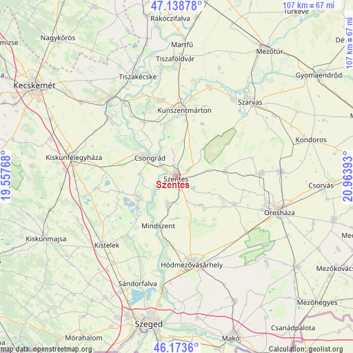
Szentes GPS coordinates[2]
46° 39' 30.024" North, 20° 15' 38.88" East
| Map corner | latitude | longitude |
|---|---|---|
| Upper-left | 47.13878°, | 19.55768° |
| Center: | 46.65834°, | 20.2608° |
| Lower-right: | 46.1736°, | 20.96393° |
| Map W x H: | 107.3×107.3 km | = 66.7×66.7mi |
| max Lat: | 48.46667° ⇑81.7% North |
| Szentes: | 46.65834° |
| min Lat: | ⇓18.3% South 45.79108° |
| min Long | Szentes | max Long |
| 16.27358° | 20.2608° | 22.68096° |
| W 67.4%⇐ | ⇒32.6% E |
Elevation
Elevation of Szentes is 80 m = 262 ft, and this is 49.7 m = 163 ft below average elevation for this country.
| Max E: |
444 m = 1457 ft | 98.9% |
| Avg. | 129.7 m = 426 ft | |
| Szentes | 80 m = 262 ft | |
Min E: |
71 m = 233 ft | 1.1% |
See also: Hungary elevation on elevation.city.
Geographical zone
Szentes is located in North temperate zone (between Tropic of Cancer and the Arctic Circle). Distance of this North polar circle is 2213.3 km =1375.3 mi to North.| Distance of | km | miles | from Szentes |
|---|---|---|---|
| North Pole | 4819.1 | 2994.4 | to North |
| Arctic Circle | 2213.3 | 1375.3 | to North |
| Tropic Cancer | 2582 | 1604.4 | to South |
| Equator | 5187.9 | 3223.6 | to South |


Nearby cities:
15 places around Szentes: (largest is in red/bold)
• Baks
17.6 km =10.9 mi,  223°
223°
• Csanytelek
12.6 km =7.8 mi,  236°
236°
• Cserkeszőlő
23.5 km =14.6 mi,  346°
346°
• Csongrád
10.9 km =6.8 mi,  304°
304°
• Fábiánsebestyén
16 km =9.9 mi,  79°
79°
• Gádoros
25.9 km =16.1 mi,  87°
87°
• Kunszentmárton
20.2 km =12.6 mi,  6°
6°
• Mindszent
15.9 km =9.9 mi,  199°
199°
• Pusztaszer
24 km =14.9 mi, 240°
• Pálmonostora
23.9 km =14.9 mi,  260°
260°
• Szegvár
8.4 km =5.2 mi, 199°
• Szelevény
16.6 km =10.3 mi,  344°
344°
• Tiszaalpár
26.4 km =16.4 mi,  310°
310°
• Tömörkény
17.2 km =10.7 mi,  254°
254°
• Ópusztaszer
23.3 km =14.5 mi,  214°
214°
Sources, notices
• [Note1] Compared only with cities in Hungary existing in our database
• [Src1] Map data: © OpenStreetMap contributors (CC-BY-SA)
• [Src2] Other city data from geonames.org with taken over terms of usage.
• [Src3] Geographical zone / Annual Mean Temperature by Robert A. Rohde @ Wikipedia
