Szegvár geodata
Szegvár (Csongrád) is a populated place; located in Hungary in Europe/Budapest (GMT+2) time zone. With population of 4,897 people, there are 304 cities with bigger population in this country. Compared to other cities in Hungary, 83.2% of cities are located further ↑North; 66.6% of cities are located further ←West and 97.3% of cities have higher elevation than Szegvár. Note1


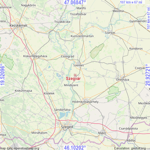
Szegvár GPS coordinates[2]
46° 35' 14.64" North, 20° 13' 26.688" East
| Map corner | latitude | longitude |
|---|---|---|
| Upper-left | 47.06847°, | 19.52096° |
| Center: | 46.5874°, | 20.22408° |
| Lower-right: | 46.10202°, | 20.92721° |
| Map W x H: | 107.5×107.5 km | = 66.8×66.8mi |
| max Lat: | 48.46667° ⇑83.2% North |
| Szegvár: | 46.5874° |
| min Lat: | ⇓16.8% South 45.79108° |
| min Long | Szegvár | max Long |
| 16.27358° | 20.22408° | 22.68096° |
| W 66.6%⇐ | ⇒33.4% E |
Elevation
Elevation of Szegvár is 82 m = 269 ft, and this is 47.7 m = 156 ft below average elevation for this country.
| Max E: |
444 m = 1457 ft | 97.3% |
| Avg. | 129.7 m = 426 ft | |
| Szegvár | 82 m = 269 ft | |
Min E: |
71 m = 233 ft | 2.7% |
See also: Hungary elevation on elevation.city.
Geographical zone
Szegvár is located in North temperate zone (between Tropic of Cancer and the Arctic Circle). Distance of this North polar circle is 2221.1 km =1380.1 mi to North.| Distance of | km | miles | from Szegvár |
|---|---|---|---|
| North Pole | 4827 | 2999.4 | to North |
| Arctic Circle | 2221.1 | 1380.1 | to North |
| Tropic Cancer | 2574.1 | 1599.5 | to South |
| Equator | 5180 | 3218.7 | to South |


Nearby cities:
15 places around Szegvár: (largest is in red/bold)
• Baks
10.6 km =6.6 mi,  242°
242°
• Balástya
24.7 km =15.3 mi,  222°
222°
• Csanytelek
7.7 km =4.8 mi,  276°
276°
• Csongrád
15.3 km =9.5 mi,  336°
336°
• Fábiánsebestyén
21.4 km =13.3 mi,  60°
60°
• Hódmezővásárhely
20.7 km =12.9 mi,  156°
156°
• Kistelek
22.6 km =14 mi, 235°
• Mindszent
7.5 km =4.7 mi,  199°
199°
• Pusztaszer
18.5 km =11.5 mi,  257°
257°
• Pálmonostora
21.2 km =13.2 mi, 281°
• Szelevény
24 km =14.9 mi,  356°
356°
• Szentes
8.4 km =5.2 mi,  19°
19°
• Székkutas
25.6 km =15.9 mi,  112°
112°
• Tömörkény
14.2 km =8.8 mi, 283°
• Ópusztaszer
15.4 km =9.6 mi, 222°
Sources, notices
• [Note1] Compared only with cities in Hungary existing in our database
• [Src1] Map data: © OpenStreetMap contributors (CC-BY-SA)
• [Src2] Other city data from geonames.org with taken over terms of usage.
• [Src3] Geographical zone / Annual Mean Temperature by Robert A. Rohde @ Wikipedia
