Rawaheng geodata
Rawaheng (Central Java) is a seat of a fourth-order administrative division; located in Indonesia in Asia/Jakarta (GMT+7) time zone. In our database, there are 407 cities with bigger population. Compared to other cities in Indonesia, 56.9% of cities are located further ↑North; 66.9% of cities are located further →East and 72.7% of cities have higher elevation than Rawaheng. Note1


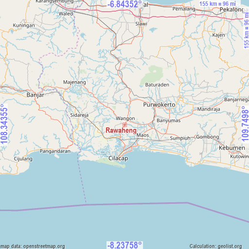
Rawaheng GPS coordinates[2]
7° 32' 27.996" South, 109° 2' 48.012" East
| Map corner | latitude | longitude |
|---|---|---|
| Upper-left | -6.84352°, | 108.34355° |
| Center: | -7.54111°, | 109.04667° |
| Lower-right: | -8.23758°, | 109.7498° |
| Map W x H: | 155×155 km | = 96.3×96.3mi |
| max Lat: | 5.88969° ⇑56.9% North |
| Rawaheng: | -7.54111° |
| min Lat: | ⇓43.1% South -10.934° |
| min Long | Rawaheng | max Long |
| 95.1345° | 109.04667° | 140.9419° |
| W 33.1%⇐ | ⇒66.9% E |
Elevation
Elevation of Rawaheng is 28 m = 92 ft, and this is 201.7 m = 662 ft below average elevation for this country.
| Max E: |
3185 m = 10449 ft | 72.7% |
| Avg. | 229.7 m = 754 ft | |
| Rawaheng | 28 m = 92 ft | |
Min E: |
-1 m = -3 ft | 27.3% |
See also: Indonesia elevation on elevation.city.
Geographical zone
Rawaheng is located in South Torrid zone (between Equator and Tropic of Capricorn). Distance of Equator is 838.5 km =521 mi to North.| Distance of | km | miles | from Rawaheng |
|---|---|---|---|
| Equator | 838.5 | 521 | to North |
| Tropic Capricorn | 1767.4 | 1098.2 | to South |
| Antarctic Circle | 6562.7 | 4077.9 | to South |
| South Pole | 9168.6 | 5697.1 | to South |


Nearby cities:
15 places around Rawaheng: (largest is in red/bold)
• Bantar Tengah
4.7 km =2.9 mi,  95°
95°
• Bantarsari Kulon
8.4 km =5.2 mi,  143°
143°
• Dawuhan
8 km =5 mi,  150°
150°
• Gerduren
5.9 km =3.7 mi,  58°
58°
• Jambuandap
3.6 km =2.2 mi,  216°
216°
• Jatilawang
8.1 km =5 mi,  84°
84°
• Kaliduren
6.1 km =3.8 mi,  110°
110°
• Klapagading
3.5 km =2.2 mi,  45°
45°
• Mandala
6.4 km =4 mi,  170°
170°
• Pekuncen
8.2 km =5.1 mi, 104°
• Prapagan
5.5 km =3.4 mi,  239°
239°
• Sangkalputung
4.3 km =2.7 mi,  24°
24°
• Sudikampir
3.8 km =2.4 mi,  325°
325°
• Tengah
7.5 km =4.7 mi, 102°
• Wangon
2.9 km =1.8 mi, 15°
Sources, notices
• [Note1] Compared only with cities in Indonesia existing in our database
• [Src1] Map data: © OpenStreetMap contributors (CC-BY-SA)
• [Src2] Other city data from geonames.org with taken over terms of usage.
• [Src3] Geographical zone / Annual Mean Temperature by Robert A. Rohde @ Wikipedia
