Mandala geodata
Mandala (Central Java) is a seat of a fourth-order administrative division; located in Indonesia in Asia/Jakarta (GMT+7) time zone. In our database, there are 407 cities with bigger population. Compared to other cities in Indonesia, 58% of cities are located further ↑North; 66.8% of cities are located further →East and 54.6% of cities have higher elevation than Mandala. Note1


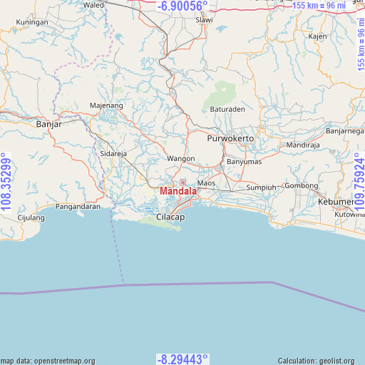
Mandala GPS coordinates[2]
7° 35' 53.016" South, 109° 3' 21.996" East
| Map corner | latitude | longitude |
|---|---|---|
| Upper-left | -6.90056°, | 108.35299° |
| Center: | -7.59806°, | 109.05611° |
| Lower-right: | -8.29443°, | 109.75924° |
| Map W x H: | 155×155 km | = 96.3×96.3mi |
| max Lat: | 5.88969° ⇑58% North |
| Mandala: | -7.59806° |
| min Lat: | ⇓42% South -10.934° |
| min Long | Mandala | max Long |
| 95.1345° | 109.05611° | 140.9419° |
| W 33.2%⇐ | ⇒66.8% E |
Elevation
Elevation of Mandala is 87 m = 285 ft, and this is 142.7 m = 468 ft below average elevation for this country.
| Max E: |
3185 m = 10449 ft | 54.6% |
| Avg. | 229.7 m = 754 ft | |
| Mandala | 87 m = 285 ft | |
Min E: |
-1 m = -3 ft | 45.4% |
See also: Indonesia elevation on elevation.city.
Geographical zone
Mandala is located in South Torrid zone (between Equator and Tropic of Capricorn). Distance of Equator is 844.8 km =524.9 mi to North.| Distance of | km | miles | from Mandala |
|---|---|---|---|
| Equator | 844.8 | 524.9 | to North |
| Tropic Capricorn | 1761.1 | 1094.3 | to South |
| Antarctic Circle | 6556.3 | 4073.9 | to South |
| South Pole | 9162.2 | 5693.1 | to South |


Nearby cities:
15 places around Mandala: (largest is in red/bold)
• Bantar Tengah
6.9 km =4.3 mi,  31°
31°
• Bantarsari Kulon
3.9 km =2.4 mi,  96°
96°
• Dawuhan
3 km =1.9 mi, 103°
• Jambuandap
4.7 km =2.9 mi,  317°
317°
• Jeruklegi
5 km =3.1 mi,  234°
234°
• Kaliduren
6.2 km =3.9 mi,  47°
47°
• Keleng
6.1 km =3.8 mi,  86°
86°
• Kesugihan
7.5 km =4.7 mi,  106°
106°
• Madusari
3.7 km =2.3 mi,  138°
138°
• Pekuncen
8.1 km =5 mi,  58°
58°
• Prapagan
6.8 km =4.2 mi,  301°
301°
• Rawaheng
6.4 km =4 mi,  350°
350°
• Sawoan
2.6 km =1.6 mi,  151°
151°
• Tengah
7.9 km =4.9 mi, 52°
• Watuagung
6.5 km =4 mi, 86°
Sources, notices
• [Note1] Compared only with cities in Indonesia existing in our database
• [Src1] Map data: © OpenStreetMap contributors (CC-BY-SA)
• [Src2] Other city data from geonames.org with taken over terms of usage.
• [Src3] Geographical zone / Annual Mean Temperature by Robert A. Rohde @ Wikipedia
