Sawoan geodata
Sawoan (Central Java) is a seat of a fourth-order administrative division; located in Indonesia in Asia/Jakarta (GMT+7) time zone. In our database, there are 407 cities with bigger population. Compared to other cities in Indonesia, 58.3% of cities are located further ↑North; 66.8% of cities are located further →East and 75.5% of cities have higher elevation than Sawoan. Note1


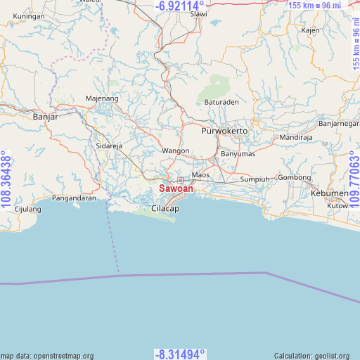
Sawoan GPS coordinates[2]
7° 37' 6.996" South, 109° 4' 3" East
| Map corner | latitude | longitude |
|---|---|---|
| Upper-left | -6.92114°, | 108.36438° |
| Center: | -7.61861°, | 109.0675° |
| Lower-right: | -8.31494°, | 109.77063° |
| Map W x H: | 155×155 km | = 96.3×96.3mi |
| max Lat: | 5.88969° ⇑58.3% North |
| Sawoan: | -7.61861° |
| min Lat: | ⇓41.7% South -10.934° |
| min Long | Sawoan | max Long |
| 95.1345° | 109.0675° | 140.9419° |
| W 33.2%⇐ | ⇒66.8% E |
Elevation
Elevation of Sawoan is 24 m = 79 ft, and this is 205.7 m = 675 ft below average elevation for this country.
| Max E: |
3185 m = 10449 ft | 75.5% |
| Avg. | 229.7 m = 754 ft | |
| Sawoan | 24 m = 79 ft | |
Min E: |
-1 m = -3 ft | 24.5% |
See also: Indonesia elevation on elevation.city.
Geographical zone
Sawoan is located in South Torrid zone (between Equator and Tropic of Capricorn). Distance of Equator is 847.1 km =526.4 mi to North.| Distance of | km | miles | from Sawoan |
|---|---|---|---|
| Equator | 847.1 | 526.4 | to North |
| Tropic Capricorn | 1758.8 | 1092.9 | to South |
| Antarctic Circle | 6554.1 | 4072.5 | to South |
| South Pole | 9160 | 5691.8 | to South |


Nearby cities:
15 places around Sawoan: (largest is in red/bold)
• Bantar Tengah
8.5 km =5.3 mi,  16°
16°
• Bantarsari Kulon
3.2 km =2 mi,  54°
54°
• Bulupayung
8.3 km =5.2 mi,  72°
72°
• Dawuhan
2.3 km =1.4 mi, 45°
• Jambuandap
7.2 km =4.5 mi,  322°
322°
• Jeruklegi
5.4 km =3.4 mi,  263°
263°
• Kaliduren
7.3 km =4.5 mi,  27°
27°
• Karangrena
6.9 km =4.3 mi,  79°
79°
• Keleng
5.5 km =3.4 mi,  61°
61°
• Kesugihan
5.9 km =3.7 mi,  88°
88°
• Madusari
1.3 km =0.8 mi,  112°
112°
• Mandala
2.6 km =1.6 mi,  331°
331°
• Rejanegara
8.1 km =5 mi,  203°
203°
• Tengah
8.6 km =5.3 mi,  35°
35°
• Watuagung
5.9 km =3.7 mi, 62°
Sources, notices
• [Note1] Compared only with cities in Indonesia existing in our database
• [Src1] Map data: © OpenStreetMap contributors (CC-BY-SA)
• [Src2] Other city data from geonames.org with taken over terms of usage.
• [Src3] Geographical zone / Annual Mean Temperature by Robert A. Rohde @ Wikipedia
