Meulaboh geodata
Meulaboh (Aceh) is a seat of a second-order administrative division; located in Indonesia in Asia/Jakarta (GMT+7) time zone. With population of 35,062 people, there are 290 cities with bigger population in this country. Compared to other cities in Indonesia, 98.9% of cities are located further ↓South; 99.6% of cities are located further →East and 95.5% of cities have higher elevation than Meulaboh. Note1


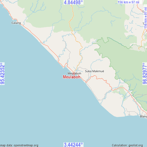
Meulaboh GPS coordinates[2]
4° 8' 38.472" North, 96° 7' 35.904" East
| Map corner | latitude | longitude |
|---|---|---|
| Upper-left | 4.84498°, | 95.42352° |
| Center: | 4.14402°, | 96.12664° |
| Lower-right: | 3.44244°, | 96.82977° |
| Map W x H: | 155.9×156 km | = 96.9×96.9mi |
| max Lat: | 5.88969° ⇑1.1% North |
| Meulaboh: | 4.14402° |
| min Lat: | ⇓98.9% South -10.934° |
| min Long | Meulaboh | max Long |
| 95.1345° | 96.12664° | 140.9419° |
| W 0.4%⇐ | ⇒99.6% E |
Elevation
Elevation of Meulaboh is 7 m = 23 ft, and this is 222.7 m = 731 ft below average elevation for this country.
| Max E: |
3185 m = 10449 ft | 95.5% |
| Avg. | 229.7 m = 754 ft | |
| Meulaboh | 7 m = 23 ft | |
Min E: |
-1 m = -3 ft | 4.5% |
See also: Indonesia elevation on elevation.city.
Geographical zone
Meulaboh is located in North Torrid zone (between Equator and Tropic of Cancer). Distance of Equator is 460.8 km =286.3 mi to South.| Distance of | km | miles | from Meulaboh |
|---|---|---|---|
| North Pole | 9546.3 | 5931.8 | to North |
| Arctic Circle | 6940.4 | 4312.6 | to North |
| Tropic Cancer | 2145.1 | 1332.9 | to North |
| Equator | 460.8 | 286.3 | to South |


Nearby cities:
15 places around Meulaboh: (largest is in red/bold)
• Alue Bilie
50.5 km =31.4 mi,  107°
107°
• Babah Rot
66.8 km =41.5 mi, 110°
• Banda Layung
11.3 km =7 mi,  343°
343°
• Beutong Ateuh
36.5 km =22.7 mi,  70°
70°
• Blang Ara
31.1 km =19.3 mi,  60°
60°
• Drien Rampak
26.3 km =16.3 mi,  314°
314°
• Geumpang
76.2 km =47.3 mi,  2°
2°
• Kajeung
41.1 km =25.5 mi, 0°
• Kalde Panga
64.6 km =40.1 mi,  315°
315°
• Keudee Aron
9.7 km =6 mi,  36°
36°
• Kuala Bhee
28.3 km =17.6 mi, 341°
• Kuala Tuha
16.1 km =10 mi,  125°
125°
• Meureubo
4 km =2.5 mi,  96°
96°
• Pantai Ceuremen
26.2 km =16.3 mi,  16°
16°
• Suka Makmue
56.7 km =35.2 mi, 106°
Sources, notices
• [Note1] Compared only with cities in Indonesia existing in our database
• [Src1] Map data: © OpenStreetMap contributors (CC-BY-SA)
• [Src2] Other city data from geonames.org with taken over terms of usage.
• [Src3] Geographical zone / Annual Mean Temperature by Robert A. Rohde @ Wikipedia
