Bambor geodata
Bambor (East Nusa Tenggara) is a seat of a fourth-order administrative division; located in Indonesia in Asia/Makassar (GMT+8) time zone. In our database, there are 407 cities with bigger population. Compared to other cities in Indonesia, 87.2% of cities are located further ↑North; 82.9% of cities are located further ←West and 85.9% of cities have lower elevation than Bambor. Note1


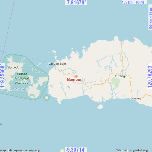
Bambor GPS coordinates[2]
8° 36' 45.36" South, 120° 3' 35.28" East
| Map corner | latitude | longitude |
|---|---|---|
| Upper-left | -7.91678°, | 119.35668° |
| Center: | -8.6126°, | 120.0598° |
| Lower-right: | -9.30714°, | 120.76293° |
| Map W x H: | 154.6×154.6 km | = 96.1×96.1mi |
| max Lat: | 5.88969° ⇑87.2% North |
| Bambor: | -8.6126° |
| min Lat: | ⇓12.8% South -10.934° |
| min Long | Bambor | max Long |
| 95.1345° | 120.0598° | 140.9419° |
| W 82.9%⇐ | ⇒17.1% E |
Elevation
Elevation of Bambor is 534 m = 1752 ft, and this is 304.3 m = 998 ft above average elevation for this country.
| Max E: |
3185 m = 10449 ft | 14.1% |
| Bambor | 534 m 1752 ft | |
| Avg. | 229.7 m = 754 ft | |
Min E: |
-1 m = -3 ft | 85.9% |
See also: Indonesia elevation on elevation.city.
Geographical zone
Bambor is located in South Torrid zone (between Equator and Tropic of Capricorn). Distance of Equator is 957.6 km =595 mi to North.| Distance of | km | miles | from Bambor |
|---|---|---|---|
| Equator | 957.6 | 595 | to North |
| Tropic Capricorn | 1648.3 | 1024.2 | to South |
| Antarctic Circle | 6443.5 | 4003.8 | to South |
| South Pole | 9049.4 | 5623 | to South |


Nearby cities:
15 places around Bambor: (largest is in red/bold)
• Betong
10.8 km =6.7 mi,  353°
353°
• Dahot
4.1 km =2.5 mi,  160°
160°
• Golondalas
5 km =3.1 mi,  294°
294°
• Handeng
12.4 km =7.7 mi,  42°
42°
• Laci
10.4 km =6.5 mi,  150°
150°
• Mberheleng
11.2 km =7 mi,  3°
3°
• Melo
11 km =6.8 mi,  278°
278°
• Ndewel
3.4 km =2.1 mi,  338°
338°
• Rambang
4.2 km =2.6 mi,  200°
200°
• Ranggawatu
1.7 km =1.1 mi,  271°
271°
• Teongtoda
7 km =4.3 mi,  241°
241°
• Tohong
8.7 km =5.4 mi,  314°
314°
• Tondongraja
3.3 km =2.1 mi,  356°
356°
• Wangkung
12.1 km =7.5 mi,  332°
332°
• Werang
6.7 km =4.2 mi,  233°
233°
Sources, notices
• [Note1] Compared only with cities in Indonesia existing in our database
• [Src1] Map data: © OpenStreetMap contributors (CC-BY-SA)
• [Src2] Other city data from geonames.org with taken over terms of usage.
• [Src3] Geographical zone / Annual Mean Temperature by Robert A. Rohde @ Wikipedia
