Jepang geodata
Jepang (Central Java) is a seat of a fourth-order administrative division; located in Indonesia in Asia/Jakarta (GMT+7) time zone. In our database, there are 407 cities with bigger population. Compared to other cities in Indonesia, 64.3% of cities are located further ↓South; 62.2% of cities are located further →East and 56.3% of cities have higher elevation than Jepang. Note1


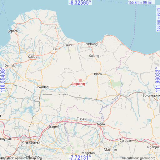
Jepang GPS coordinates[2]
7° 1' 26.4" South, 111° 15' 25.92" East
| Map corner | latitude | longitude |
|---|---|---|
| Upper-left | -6.32565°, | 110.55408° |
| Center: | -7.024°, | 111.2572° |
| Lower-right: | -7.72131°, | 111.96033° |
| Map W x H: | 155.2×155.2 km | = 96.4×96.4mi |
| max Lat: | 5.88969° ⇑35.7% North |
| Jepang: | -7.024° |
| min Lat: | ⇓64.3% South -10.934° |
| min Long | Jepang | max Long |
| 95.1345° | 111.2572° | 140.9419° |
| W 37.8%⇐ | ⇒62.2% E |
Elevation
Elevation of Jepang is 77 m = 253 ft, and this is 152.7 m = 501 ft below average elevation for this country.
| Max E: |
3185 m = 10449 ft | 56.3% |
| Avg. | 229.7 m = 754 ft | |
| Jepang | 77 m = 253 ft | |
Min E: |
-1 m = -3 ft | 43.7% |
See also: Indonesia elevation on elevation.city.
Geographical zone
Jepang is located in South Torrid zone (between Equator and Tropic of Capricorn). Distance of Equator is 781 km =485.3 mi to North.| Distance of | km | miles | from Jepang |
|---|---|---|---|
| Equator | 781 | 485.3 | to North |
| Tropic Capricorn | 1824.9 | 1133.9 | to South |
| Antarctic Circle | 6620.2 | 4113.6 | to South |
| South Pole | 9226.1 | 5732.8 | to South |


Nearby cities:
15 places around Jepang: (largest is in red/bold)
• Balong Wetan
2.6 km =1.6 mi,  9°
9°
• Bradag
5.4 km =3.4 mi,  50°
50°
• Jagong
2.7 km =1.7 mi,  188°
188°
• Jetak
1.1 km =0.7 mi,  140°
140°
• Krocok
6 km =3.7 mi,  19°
19°
• Muraharjo
2.6 km =1.6 mi,  158°
158°
• Pecaren
5.1 km =3.2 mi,  68°
68°
• Pelem
4.7 km =2.9 mi,  1°
1°
• Pipes
5.4 km =3.4 mi,  145°
145°
• Plosorejo
3.6 km =2.2 mi, 7°
• Plumbon
5 km =3.1 mi,  130°
130°
• Punggursugih
6 km =3.7 mi,  78°
78°
• Talok
5.3 km =3.3 mi,  96°
96°
• Tengger
6.2 km =3.9 mi, 46°
• Trembulrejo
5.5 km =3.4 mi,  85°
85°
Sources, notices
• [Note1] Compared only with cities in Indonesia existing in our database
• [Src1] Map data: © OpenStreetMap contributors (CC-BY-SA)
• [Src2] Other city data from geonames.org with taken over terms of usage.
• [Src3] Geographical zone / Annual Mean Temperature by Robert A. Rohde @ Wikipedia
