Muraharjo geodata
Muraharjo (Central Java) is a seat of a fourth-order administrative division; located in Indonesia in Asia/Jakarta (GMT+7) time zone. In our database, there are 407 cities with bigger population. Compared to other cities in Indonesia, 62.9% of cities are located further ↓South; 62.1% of cities are located further →East and 56.8% of cities have higher elevation than Muraharjo. Note1


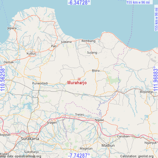
Muraharjo GPS coordinates[2]
7° 2' 44.16" South, 111° 15' 56.52" East
| Map corner | latitude | longitude |
|---|---|---|
| Upper-left | -6.34728°, | 110.56258° |
| Center: | -7.0456°, | 111.2657° |
| Lower-right: | -7.74287°, | 111.96883° |
| Map W x H: | 155.2×155.2 km | = 96.4×96.4mi |
| max Lat: | 5.88969° ⇑37.1% North |
| Muraharjo: | -7.0456° |
| min Lat: | ⇓62.9% South -10.934° |
| min Long | Muraharjo | max Long |
| 95.1345° | 111.2657° | 140.9419° |
| W 37.9%⇐ | ⇒62.1% E |
Elevation
Elevation of Muraharjo is 74 m = 243 ft, and this is 155.7 m = 511 ft below average elevation for this country.
| Max E: |
3185 m = 10449 ft | 56.8% |
| Avg. | 229.7 m = 754 ft | |
| Muraharjo | 74 m = 243 ft | |
Min E: |
-1 m = -3 ft | 43.2% |
See also: Indonesia elevation on elevation.city.
Geographical zone
Muraharjo is located in South Torrid zone (between Equator and Tropic of Capricorn). Distance of Equator is 783.4 km =486.8 mi to North.| Distance of | km | miles | from Muraharjo |
|---|---|---|---|
| Equator | 783.4 | 486.8 | to North |
| Tropic Capricorn | 1822.5 | 1132.4 | to South |
| Antarctic Circle | 6617.8 | 4112.1 | to South |
| South Pole | 9223.7 | 5731.3 | to South |


Nearby cities:
15 places around Muraharjo: (largest is in red/bold)
• Balong Wetan
5 km =3.1 mi,  354°
354°
• Bradag
6.7 km =4.2 mi,  29°
29°
• Jagong
1.4 km =0.9 mi,  258°
258°
• Jepang
2.6 km =1.6 mi,  338°
338°
• Jetak
1.5 km =0.9 mi, 352°
• Karangtengah
5.7 km =3.5 mi,  83°
83°
• Kendayakan
4.9 km =3 mi,  99°
99°
• Ketanggi
6.5 km =4 mi,  59°
59°
• Pecaren
5.7 km =3.5 mi,  41°
41°
• Pipes
3 km =1.9 mi,  135°
135°
• Plosorejo
6 km =3.7 mi,  355°
355°
• Plumbon
3 km =1.9 mi,  106°
106°
• Punggursugih
6.1 km =3.8 mi,  54°
54°
• Talok
4.7 km =2.9 mi,  67°
67°
• Trembulrejo
5.4 km =3.4 mi, 57°
Sources, notices
• [Note1] Compared only with cities in Indonesia existing in our database
• [Src1] Map data: © OpenStreetMap contributors (CC-BY-SA)
• [Src2] Other city data from geonames.org with taken over terms of usage.
• [Src3] Geographical zone / Annual Mean Temperature by Robert A. Rohde @ Wikipedia
