Rambang geodata
Rambang (East Nusa Tenggara) is a seat of a fourth-order administrative division; located in Indonesia in Asia/Makassar (GMT+8) time zone. In our database, there are 407 cities with bigger population. Compared to other cities in Indonesia, 88.1% of cities are located further ↑North; 82.8% of cities are located further ←West and 90% of cities have lower elevation than Rambang. Note1


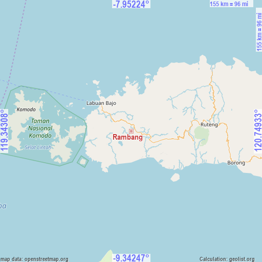
Rambang GPS coordinates[2]
8° 38' 52.8" South, 120° 2' 46.32" East
| Map corner | latitude | longitude |
|---|---|---|
| Upper-left | -7.95224°, | 119.34308° |
| Center: | -8.648°, | 120.0462° |
| Lower-right: | -9.34247°, | 120.74933° |
| Map W x H: | 154.6×154.6 km | = 96.1×96.1mi |
| max Lat: | 5.88969° ⇑88.1% North |
| Rambang: | -8.648° |
| min Lat: | ⇓11.9% South -10.934° |
| min Long | Rambang | max Long |
| 95.1345° | 120.0462° | 140.9419° |
| W 82.8%⇐ | ⇒17.2% E |
Elevation
Elevation of Rambang is 642 m = 2106 ft, and this is 412.3 m = 1353 ft above average elevation for this country.
| Max E: |
3185 m = 10449 ft | 10% |
| Rambang | 642 m 2106 ft | |
| Avg. | 229.7 m = 754 ft | |
Min E: |
-1 m = -3 ft | 90% |
See also: Indonesia elevation on elevation.city.
Geographical zone
Rambang is located in South Torrid zone (between Equator and Tropic of Capricorn). Distance of Equator is 961.6 km =597.5 mi to North.| Distance of | km | miles | from Rambang |
|---|---|---|---|
| Equator | 961.6 | 597.5 | to North |
| Tropic Capricorn | 1644.4 | 1021.8 | to South |
| Antarctic Circle | 6439.6 | 4001.4 | to South |
| South Pole | 9045.5 | 5620.6 | to South |


Nearby cities:
15 places around Rambang: (largest is in red/bold)
• Bambor
4.2 km =2.6 mi,  20°
20°
• Betong
14.7 km =9.1 mi,  1°
1°
• Dahot
2.9 km =1.8 mi,  88°
88°
• Dalong
15.2 km =9.4 mi,  307°
307°
• Golondalas
6.8 km =4.2 mi,  332°
332°
• Laci
8.4 km =5.2 mi,  127°
127°
• Melo
10.9 km =6.8 mi,  300°
300°
• Ndewel
7.1 km =4.4 mi, 2°
• Nunang
9.2 km =5.7 mi,  209°
209°
• Ranggawatu
4 km =2.5 mi,  357°
357°
• Teongtoda
4.7 km =2.9 mi,  276°
276°
• Tohong
11.1 km =6.9 mi, 334°
• Tondongraja
7.3 km =4.5 mi,  10°
10°
• Wangkung
15.2 km =9.4 mi,  344°
344°
• Werang
3.9 km =2.4 mi,  268°
268°
Sources, notices
• [Note1] Compared only with cities in Indonesia existing in our database
• [Src1] Map data: © OpenStreetMap contributors (CC-BY-SA)
• [Src2] Other city data from geonames.org with taken over terms of usage.
• [Src3] Geographical zone / Annual Mean Temperature by Robert A. Rohde @ Wikipedia
