Wolowaru geodata
Wolowaru (East Nusa Tenggara) is a seat of a third-order administrative division; located in Indonesia in Asia/Makassar (GMT+8) time zone. In our database, there are 407 cities with bigger population. Compared to other cities in Indonesia, 91.1% of cities are located further ↑North; 87.7% of cities are located further ←West and 66.2% of cities have lower elevation than Wolowaru. Note1


Wolowaru GPS coordinates[2]
8° 47' 0.6" South, 121° 53' 9.6" East
| Map corner | latitude | longitude |
|---|---|---|
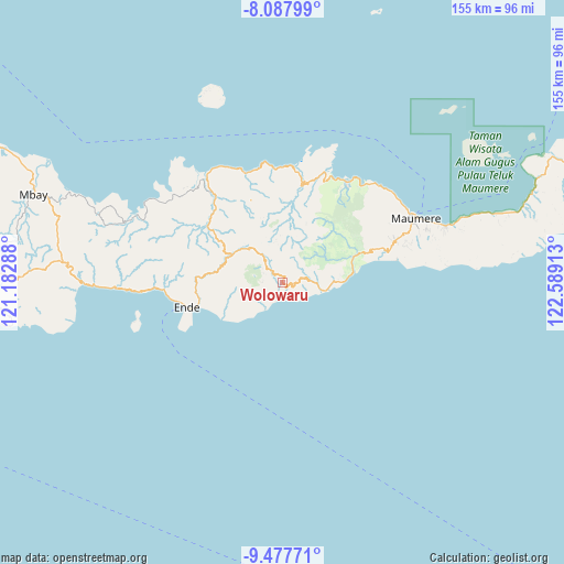
| Upper-left | -8.08799°, | 121.18288° |
| Center: | -8.7835°, | 121.886° |
| Lower-right: | -9.47771°, | 122.58913° |
| Map W x H: | 154.5×154.5 km | = 96×96mi |
| max Lat: | 5.88969° ⇑91.1% North |
| Wolowaru: | -8.7835° |
| min Lat: | ⇓8.9% South -10.934° |
| min Long | Wolowaru | max Long |
| 95.1345° | 121.886° | 140.9419° |
| W 87.7%⇐ | ⇒12.3% E |
Elevation
Elevation of Wolowaru is 240 m = 787 ft, and this is 10.3 m = 34 ft above average elevation for this country.
| Max E: |
3185 m = 10449 ft | 33.8% |
| Wolowaru | 240 m 787 ft | |
| Avg. | 229.7 m = 754 ft | |
Min E: |
-1 m = -3 ft | 66.2% |
See also: Indonesia elevation on elevation.city.
Geographical zone
Wolowaru is located in South Torrid zone (between Equator and Tropic of Capricorn). Distance of Equator is 976.6 km =606.8 mi to North.| Distance of | km | miles | from Wolowaru |
|---|---|---|---|
| Equator | 976.6 | 606.8 | to North |
| Tropic Capricorn | 1629.3 | 1012.4 | to South |
| Antarctic Circle | 6424.5 | 3992 | to South |
| South Pole | 9030.4 | 5611.2 | to South |


Nearby cities:
15 places around Wolowaru: (largest is in red/bold)
• Aemalu
6.7 km =4.2 mi,  72°
72°
• Aeteke
10.3 km =6.4 mi,  100°
100°
• Aipetu
10 km =6.2 mi, 97°
• Baolokan
0.9 km =0.6 mi,  18°
18°
• Jitapanda
7.8 km =4.8 mi,  84°
84°
• Koanara
5.4 km =3.4 mi,  316°
316°
• Liabeke
4.6 km =2.9 mi, 80°
• Maubasa
7 km =4.3 mi,  132°
132°
• Nduaria
10.2 km =6.3 mi, 321°
• Ratenggoji
11.4 km =7.1 mi, 16°
• Woloara
9.9 km =6.2 mi, 65°
• Wolobela
9.1 km =5.7 mi,  55°
55°
• Wololele A
4.4 km =2.7 mi,  47°
47°
• Wololele B
2.5 km =1.6 mi, 17°
• Wonda
5.7 km =3.5 mi, 98°
Sources, notices
• [Note1] Compared only with cities in Indonesia existing in our database
• [Src1] Map data: © OpenStreetMap contributors (CC-BY-SA)
• [Src2] Other city data from geonames.org with taken over terms of usage.
• [Src3] Geographical zone / Annual Mean Temperature by Robert A. Rohde @ Wikipedia
