Magetlegar geodata
Magetlegar (East Nusa Tenggara) is a seat of a fourth-order administrative division; located in Indonesia in Asia/Makassar (GMT+8) time zone. In our database, there are 407 cities with bigger population. Compared to other cities in Indonesia, 89.3% of cities are located further ↑North; 88.9% of cities are located further ←West and 88.3% of cities have lower elevation than Magetlegar. Note1


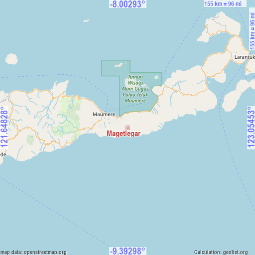
Magetlegar GPS coordinates[2]
8° 41' 54.96" South, 122° 21' 5.04" East
| Map corner | latitude | longitude |
|---|---|---|
| Upper-left | -8.00293°, | 121.64828° |
| Center: | -8.6986°, | 122.3514° |
| Lower-right: | -9.39298°, | 123.05453° |
| Map W x H: | 154.6×154.6 km | = 96.1×96.1mi |
| max Lat: | 5.88969° ⇑89.3% North |
| Magetlegar: | -8.6986° |
| min Lat: | ⇓10.7% South -10.934° |
| min Long | Magetlegar | max Long |
| 95.1345° | 122.3514° | 140.9419° |
| W 88.9%⇐ | ⇒11.1% E |
Elevation
Elevation of Magetlegar is 592 m = 1942 ft, and this is 362.3 m = 1189 ft above average elevation for this country.
| Max E: |
3185 m = 10449 ft | 11.7% |
| Magetlegar | 592 m 1942 ft | |
| Avg. | 229.7 m = 754 ft | |
Min E: |
-1 m = -3 ft | 88.3% |
See also: Indonesia elevation on elevation.city.
Geographical zone
Magetlegar is located in South Torrid zone (between Equator and Tropic of Capricorn). Distance of Equator is 967.2 km =601 mi to North.| Distance of | km | miles | from Magetlegar |
|---|---|---|---|
| Equator | 967.2 | 601 | to North |
| Tropic Capricorn | 1638.7 | 1018.2 | to South |
| Antarctic Circle | 6434 | 3997.9 | to South |
| South Pole | 9039.9 | 5617.1 | to South |


Nearby cities:
15 places around Magetlegar: (largest is in red/bold)
• Aibura
4.1 km =2.5 mi,  328°
328°
• Baluk
7.1 km =4.4 mi,  226°
226°
• Baobatun
7.8 km =4.8 mi,  279°
279°
• Bei
8.9 km =5.5 mi,  268°
268°
• Bola
7.8 km =4.8 mi, 231°
• Habibola
6 km =3.7 mi,  159°
159°
• Kawapante
8.5 km =5.3 mi,  313°
313°
• Kloangpopot
1.4 km =0.9 mi,  178°
178°
• Kloangrotat
2.8 km =1.7 mi,  320°
320°
• Nangahaledoi
8.2 km =5.1 mi, 334°
• Natakoli
8.5 km =5.3 mi,  101°
101°
• Nitakloang
7.7 km =4.8 mi,  301°
301°
• Potet
5.1 km =3.2 mi,  290°
290°
• Watublapi
4.2 km =2.6 mi, 266°
• Wolokoli
8.5 km =5.3 mi,  247°
247°
Sources, notices
• [Note1] Compared only with cities in Indonesia existing in our database
• [Src1] Map data: © OpenStreetMap contributors (CC-BY-SA)
• [Src2] Other city data from geonames.org with taken over terms of usage.
• [Src3] Geographical zone / Annual Mean Temperature by Robert A. Rohde @ Wikipedia
