Malapedo B geodata
Malapedo B (East Nusa Tenggara) is a seat of a fourth-order administrative division; located in Indonesia in Asia/Makassar (GMT+8) time zone. In our database, there are 407 cities with bigger population. Compared to other cities in Indonesia, 92.6% of cities are located further ↑North; 85.4% of cities are located further ←West and 69.5% of cities have higher elevation than Malapedo B. Note1


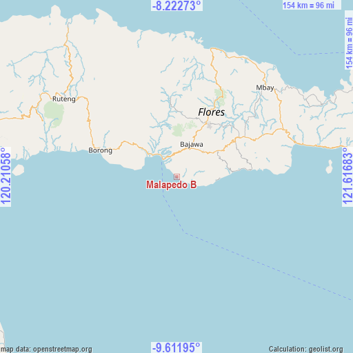
Malapedo B GPS coordinates[2]
8° 55' 4.8" South, 120° 54' 49.32" East
| Map corner | latitude | longitude |
|---|---|---|
| Upper-left | -8.22273°, | 120.21058° |
| Center: | -8.918°, | 120.9137° |
| Lower-right: | -9.61195°, | 121.61683° |
| Map W x H: | 154.5×154.5 km | = 96×96mi |
| max Lat: | 5.88969° ⇑92.6% North |
| Malapedo B: | -8.918° |
| min Lat: | ⇓7.4% South -10.934° |
| min Long | Malapedo B | max Long |
| 95.1345° | 120.9137° | 140.9419° |
| W 85.4%⇐ | ⇒14.6% E |
Elevation
Elevation of Malapedo B is 33 m = 108 ft, and this is 196.7 m = 645 ft below average elevation for this country.
| Max E: |
3185 m = 10449 ft | 69.5% |
| Avg. | 229.7 m = 754 ft | |
| Malapedo B | 33 m = 108 ft | |
Min E: |
-1 m = -3 ft | 30.5% |
See also: Indonesia elevation on elevation.city.
Geographical zone
Malapedo B is located in South Torrid zone (between Equator and Tropic of Capricorn). Distance of Equator is 991.6 km =616.2 mi to North.| Distance of | km | miles | from Malapedo B |
|---|---|---|---|
| Equator | 991.6 | 616.2 | to North |
| Tropic Capricorn | 1614.3 | 1003.1 | to South |
| Antarctic Circle | 6409.6 | 3982.7 | to South |
| South Pole | 9015.5 | 5602 | to South |


Nearby cities:
15 places around Malapedo B: (largest is in red/bold)
• Aimere
10.3 km =6.4 mi,  323°
323°
• Bojawa
10.6 km =6.6 mi,  28°
28°
• Bosiko
14.7 km =9.1 mi,  35°
35°
• Dona
12.4 km =7.7 mi,  81°
81°
• Gurusina
8.8 km =5.5 mi,  74°
74°
• Malabhaga
10.8 km =6.7 mi, 69°
• Mari
11.3 km =7 mi, 27°
• Ngedhusuba
13.6 km =8.5 mi,  107°
107°
• Nuamuzi
12.8 km =8 mi,  57°
57°
• Paukate
13.4 km =8.3 mi,  330°
330°
• Pomasule
1.4 km =0.9 mi, 317°
• Ruto
1.5 km =0.9 mi,  122°
122°
• Rutojawa
11.1 km =6.9 mi,  87°
87°
• Waebela
7.1 km =4.4 mi, 112°
• Warekeo
13.4 km =8.3 mi,  52°
52°
Sources, notices
• [Note1] Compared only with cities in Indonesia existing in our database
• [Src1] Map data: © OpenStreetMap contributors (CC-BY-SA)
• [Src2] Other city data from geonames.org with taken over terms of usage.
• [Src3] Geographical zone / Annual Mean Temperature by Robert A. Rohde @ Wikipedia
