Kedondong geodata
Kedondong (Lampung) is a seat of a third-order administrative division; located in Indonesia in Asia/Jakarta (GMT+7) time zone. In our database, there are 407 cities with bigger population. Compared to other cities in Indonesia, 88.3% of cities are located further ↓South; 94.6% of cities are located further →East and 54.3% of cities have lower elevation than Kedondong. Note1


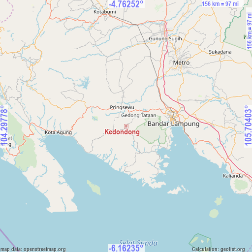
Kedondong GPS coordinates[2]
5° 27' 46.224" South, 105° 0' 3.24" East
| Map corner | latitude | longitude |
|---|---|---|
| Upper-left | -4.76252°, | 104.29778° |
| Center: | -5.46284°, | 105.0009° |
| Lower-right: | -6.16235°, | 105.70403° |
| Map W x H: | 155.6×155.7 km | = 96.7×96.7mi |
| max Lat: | 5.88969° ⇑11.7% North |
| Kedondong: | -5.46284° |
| min Lat: | ⇓88.3% South -10.934° |
| min Long | Kedondong | max Long |
| 95.1345° | 105.0009° | 140.9419° |
| W 5.4%⇐ | ⇒94.6% E |
Elevation
Elevation of Kedondong is 121 m = 397 ft, and this is 108.7 m = 357 ft below average elevation for this country.
| Max E: |
3185 m = 10449 ft | 45.7% |
| Avg. | 229.7 m = 754 ft | |
| Kedondong | 121 m = 397 ft | |
Min E: |
-1 m = -3 ft | 54.3% |
See also: Indonesia elevation on elevation.city.
Geographical zone
Kedondong is located in South Torrid zone (between Equator and Tropic of Capricorn). Distance of Equator is 607.4 km =377.4 mi to North.| Distance of | km | miles | from Kedondong |
|---|---|---|---|
| Equator | 607.4 | 377.4 | to North |
| Tropic Capricorn | 1998.5 | 1241.8 | to South |
| Antarctic Circle | 6793.8 | 4221.5 | to South |
| South Pole | 9399.7 | 5840.7 | to South |


Nearby cities:
15 places around Kedondong: (largest is in red/bold)
• Bandar Lampung
29 km =18 mi,  82°
82°
• Bangunrejo
36.1 km =22.4 mi,  6°
6°
• Gadingrejo
12.1 km =7.5 mi,  33°
33°
• Gedong Tataan
13.7 km =8.5 mi,  49°
49°
• Kalirejo
26.7 km =16.6 mi,  350°
350°
• Kedaton
30 km =18.6 mi,  72°
72°
• Kota Agung
39.6 km =24.6 mi,  263°
263°
• Kotaagung
42.1 km =26.2 mi,  265°
265°
• Metro
51.6 km =32.1 mi,  41°
41°
• Natar
27.3 km =17 mi, 51°
• Padangcermin
21.6 km =13.4 mi,  135°
135°
• Panjang
35.3 km =21.9 mi,  92°
92°
• Pringsewu
12 km =7.5 mi, 345°
• Pulaupanggung
32.9 km =20.4 mi,  299°
299°
• Sukoharjo Satu
18.1 km =11.2 mi, 353°
Sources, notices
• [Note1] Compared only with cities in Indonesia existing in our database
• [Src1] Map data: © OpenStreetMap contributors (CC-BY-SA)
• [Src2] Other city data from geonames.org with taken over terms of usage.
• [Src3] Geographical zone / Annual Mean Temperature by Robert A. Rohde @ Wikipedia
