Penikebon geodata
Penikebon (Banten) is a seat of a fourth-order administrative division; located in Indonesia in Asia/Jakarta (GMT+7) time zone. In our database, there are 407 cities with bigger population. Compared to other cities in Indonesia, 86.3% of cities are located further ↓South; 89.8% of cities are located further →East and 63.1% of cities have lower elevation than Penikebon. Note1


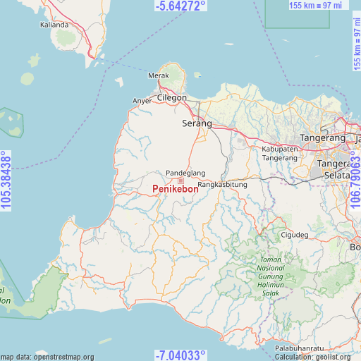
Penikebon GPS coordinates[2]
6° 20' 31.2" South, 106° 5' 15" East
| Map corner | latitude | longitude |
|---|---|---|
| Upper-left | -5.64272°, | 105.38438° |
| Center: | -6.342°, | 106.0875° |
| Lower-right: | -7.04033°, | 106.79063° |
| Map W x H: | 155.4×155.4 km | = 96.6×96.6mi |
| max Lat: | 5.88969° ⇑13.7% North |
| Penikebon: | -6.342° |
| min Lat: | ⇓86.3% South -10.934° |
| min Long | Penikebon | max Long |
| 95.1345° | 106.0875° | 140.9419° |
| W 10.2%⇐ | ⇒89.8% E |
Elevation
Elevation of Penikebon is 198 m = 650 ft, and this is 31.7 m = 104 ft below average elevation for this country.
| Max E: |
3185 m = 10449 ft | 36.9% |
| Avg. | 229.7 m = 754 ft | |
| Penikebon | 198 m = 650 ft | |
Min E: |
-1 m = -3 ft | 63.1% |
See also: Indonesia elevation on elevation.city.
Geographical zone
Penikebon is located in South Torrid zone (between Equator and Tropic of Capricorn). Distance of Equator is 705.2 km =438.2 mi to North.| Distance of | km | miles | from Penikebon |
|---|---|---|---|
| Equator | 705.2 | 438.2 | to North |
| Tropic Capricorn | 1900.8 | 1181.1 | to South |
| Antarctic Circle | 6696 | 4160.7 | to South |
| South Pole | 9301.9 | 5779.9 | to South |


Nearby cities:
15 places around Penikebon: (largest is in red/bold)
• Babakan
1.9 km =1.2 mi,  234°
234°
• Cibebek
1.2 km =0.7 mi,  272°
272°
• Ciekek
2.7 km =1.7 mi,  29°
29°
• Cilaja
3.3 km =2.1 mi,  6°
6°
• Cipacung Landeuh
1.5 km =0.9 mi,  339°
339°
• Curuggaru
2.3 km =1.4 mi,  264°
264°
• Girihieum
2.3 km =1.4 mi,  298°
298°
• Gunungputri
2.2 km =1.4 mi,  161°
161°
• Kadomas
2.9 km =1.8 mi,  60°
60°
• Kadubincarung
2.6 km =1.6 mi,  116°
116°
• Kadugedong
2.8 km =1.7 mi,  150°
150°
• Majamasjid
1.6 km =1 mi,  22°
22°
• Rancapiit
2.9 km =1.8 mi,  172°
172°
• Rokoy
3.1 km =1.9 mi,  288°
288°
• Salinggara
2.6 km =1.6 mi,  200°
200°
Sources, notices
• [Note1] Compared only with cities in Indonesia existing in our database
• [Src1] Map data: © OpenStreetMap contributors (CC-BY-SA)
• [Src2] Other city data from geonames.org with taken over terms of usage.
• [Src3] Geographical zone / Annual Mean Temperature by Robert A. Rohde @ Wikipedia
