Cipacung Landeuh geodata
Cipacung Landeuh (Banten) is a seat of a fourth-order administrative division; located in Indonesia in Asia/Jakarta (GMT+7) time zone. In our database, there are 407 cities with bigger population. Compared to other cities in Indonesia, 86.5% of cities are located further ↓South; 89.9% of cities are located further →East and 66.8% of cities have lower elevation than Cipacung Landeuh. Note1


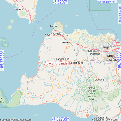
Cipacung Landeuh GPS coordinates[2]
6° 19' 44.4" South, 106° 4' 57" East
| Map corner | latitude | longitude |
|---|---|---|
| Upper-left | -5.6297°, | 105.37938° |
| Center: | -6.329°, | 106.0825° |
| Lower-right: | -7.02735°, | 106.78563° |
| Map W x H: | 155.4×155.4 km | = 96.6×96.6mi |
| max Lat: | 5.88969° ⇑13.5% North |
| Cipacung Landeuh: | -6.329° |
| min Lat: | ⇓86.5% South -10.934° |
| min Long | Cipacung Landeu | max Long |
| 95.1345° | 106.0825° | 140.9419° |
| W 10.1%⇐ | ⇒89.9% E |
Elevation
Elevation of Cipacung Landeuh is 249 m = 817 ft, and this is 19.3 m = 63 ft above average elevation for this country.
| Max E: |
3185 m = 10449 ft | 33.2% |
| Cipacung Landeuh | 249 m 817 ft | |
| Avg. | 229.7 m = 754 ft | |
Min E: |
-1 m = -3 ft | 66.8% |
See also: Indonesia elevation on elevation.city.
Geographical zone
Cipacung Landeuh is located in South Torrid zone (between Equator and Tropic of Capricorn). Distance of Equator is 703.7 km =437.3 mi to North.| Distance of | km | miles | from Cipacung Landeuh |
|---|---|---|---|
| Equator | 703.7 | 437.3 | to North |
| Tropic Capricorn | 1902.2 | 1182 | to South |
| Antarctic Circle | 6697.5 | 4161.6 | to South |
| South Pole | 9303.3 | 5780.8 | to South |


Nearby cities:
15 places around Cipacung Landeuh: (largest is in red/bold)
• Babakan
2.7 km =1.7 mi,  201°
201°
• Campraksanta
3.1 km =1.9 mi,  349°
349°
• Cibebek
1.5 km =0.9 mi, 204°
• Cidahu
3.5 km =2.2 mi,  304°
304°
• Ciekek
2.1 km =1.3 mi,  63°
63°
• Cilaja
2 km =1.2 mi,  27°
27°
• Curuggaru
2.4 km =1.5 mi,  226°
226°
• Gardutanjak
2.7 km =1.7 mi,  49°
49°
• Girihieum
1.5 km =0.9 mi,  257°
257°
• Kadomas
3.1 km =1.9 mi,  90°
90°
• Keboncau
3.5 km =2.2 mi, 45°
• Majamasjid
1.2 km =0.7 mi, 88°
• Pandeglang
3.5 km =2.2 mi, 49°
• Penikebon
1.5 km =0.9 mi,  159°
159°
• Rokoy
2.5 km =1.6 mi, 260°
Sources, notices
• [Note1] Compared only with cities in Indonesia existing in our database
• [Src1] Map data: © OpenStreetMap contributors (CC-BY-SA)
• [Src2] Other city data from geonames.org with taken over terms of usage.
• [Src3] Geographical zone / Annual Mean Temperature by Robert A. Rohde @ Wikipedia
