Watuwawer geodata
Watuwawer (East Nusa Tenggara) is a seat of a fourth-order administrative division; located in Indonesia in Asia/Makassar (GMT+8) time zone. In our database, there are 407 cities with bigger population. Compared to other cities in Indonesia, 83.7% of cities are located further ↑North; 92.6% of cities are located further ←West and 89.9% of cities have lower elevation than Watuwawer. Note1


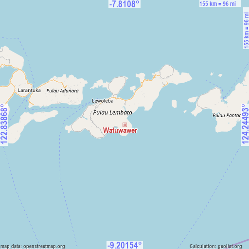
Watuwawer GPS coordinates[2]
8° 30' 24.48" South, 123° 32' 30.48" East
| Map corner | latitude | longitude |
|---|---|---|
| Upper-left | -7.8108°, | 122.83868° |
| Center: | -8.5068°, | 123.5418° |
| Lower-right: | -9.20154°, | 124.24493° |
| Map W x H: | 154.6×154.6 km | = 96.1×96.1mi |
| max Lat: | 5.88969° ⇑83.7% North |
| Watuwawer: | -8.5068° |
| min Lat: | ⇓16.3% South -10.934° |
| min Long | Watuwawer | max Long |
| 95.1345° | 123.5418° | 140.9419° |
| W 92.6%⇐ | ⇒7.4% E |
Elevation
Elevation of Watuwawer is 639 m = 2096 ft, and this is 409.3 m = 1343 ft above average elevation for this country.
| Max E: |
3185 m = 10449 ft | 10.1% |
| Watuwawer | 639 m 2096 ft | |
| Avg. | 229.7 m = 754 ft | |
Min E: |
-1 m = -3 ft | 89.9% |
See also: Indonesia elevation on elevation.city.
Geographical zone
Watuwawer is located in South Torrid zone (between Equator and Tropic of Capricorn). Distance of Equator is 945.9 km =587.8 mi to North.| Distance of | km | miles | from Watuwawer |
|---|---|---|---|
| Equator | 945.9 | 587.8 | to North |
| Tropic Capricorn | 1660.1 | 1031.5 | to South |
| Antarctic Circle | 6455.3 | 4011.1 | to South |
| South Pole | 9061.2 | 5630.4 | to South |


Nearby cities:
15 places around Watuwawer: (largest is in red/bold)
• Atawolo
2.2 km =1.4 mi,  252°
252°
• Bakan
9 km =5.6 mi,  300°
300°
• Kalikasa
11.5 km =7.1 mi,  314°
314°
• Karangora
7.5 km =4.7 mi,  330°
330°
• Kolirerek
10.4 km =6.5 mi, 311°
• Labala
5.6 km =3.5 mi,  261°
261°
• Lerek
1.8 km =1.1 mi,  166°
166°
• Lewuka
10.4 km =6.5 mi,  275°
275°
• Luki
10.1 km =6.3 mi, 254°
• Mulandoro
4.9 km =3 mi,  225°
225°
• Mulankera
6.3 km =3.9 mi, 260°
• Paulolong
5 km =3.1 mi,  293°
293°
• Tobilolong
1.7 km =1.1 mi,  204°
204°
• Waiwejak
2.3 km =1.4 mi, 293°
• Watugolok
10.7 km =6.6 mi,  315°
315°
Sources, notices
• [Note1] Compared only with cities in Indonesia existing in our database
• [Src1] Map data: © OpenStreetMap contributors (CC-BY-SA)
• [Src2] Other city data from geonames.org with taken over terms of usage.
• [Src3] Geographical zone / Annual Mean Temperature by Robert A. Rohde @ Wikipedia
