Lewonara geodata
Lewonara (East Nusa Tenggara) is a seat of a fourth-order administrative division; located in Indonesia in Asia/Makassar (GMT+8) time zone. In our database, there are 407 cities with bigger population. Compared to other cities in Indonesia, 79% of cities are located further ↑North; 91.1% of cities are located further ←West and 80.1% of cities have lower elevation than Lewonara. Note1


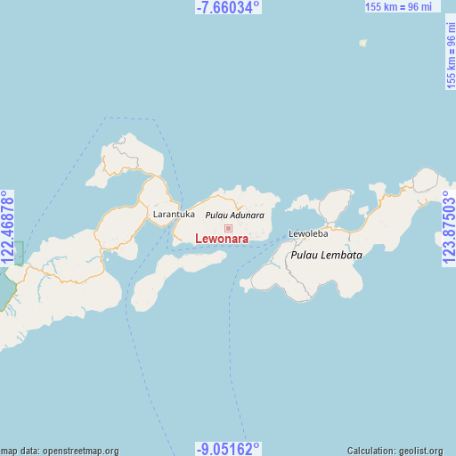
Lewonara GPS coordinates[2]
8° 21' 23.76" South, 123° 10' 18.84" East
| Map corner | latitude | longitude |
|---|---|---|
| Upper-left | -7.66034°, | 122.46878° |
| Center: | -8.3566°, | 123.1719° |
| Lower-right: | -9.05162°, | 123.87503° |
| Map W x H: | 154.7×154.7 km | = 96.1×96.1mi |
| max Lat: | 5.88969° ⇑79% North |
| Lewonara: | -8.3566° |
| min Lat: | ⇓21% South -10.934° |
| min Long | Lewonara | max Long |
| 95.1345° | 123.1719° | 140.9419° |
| W 91.1%⇐ | ⇒8.9% E |
Elevation
Elevation of Lewonara is 433 m = 1421 ft, and this is 203.3 m = 667 ft above average elevation for this country.
| Max E: |
3185 m = 10449 ft | 19.9% |
| Lewonara | 433 m 1421 ft | |
| Avg. | 229.7 m = 754 ft | |
Min E: |
-1 m = -3 ft | 80.1% |
See also: Indonesia elevation on elevation.city.
Geographical zone
Lewonara is located in South Torrid zone (between Equator and Tropic of Capricorn). Distance of Equator is 929.2 km =577.4 mi to North.| Distance of | km | miles | from Lewonara |
|---|---|---|---|
| Equator | 929.2 | 577.4 | to North |
| Tropic Capricorn | 1676.8 | 1041.9 | to South |
| Antarctic Circle | 6472 | 4021.5 | to South |
| South Pole | 9077.9 | 5640.7 | to South |


Nearby cities:
15 places around Lewonara: (largest is in red/bold)
• Ipiebang
4.5 km =2.8 mi,  255°
255°
• Lamahala
4.3 km =2.7 mi,  212°
212°
• Lamalouk
5 km =3.1 mi,  68°
68°
• Lamaluwo
2.4 km =1.5 mi,  306°
306°
• Lewolen
4.4 km =2.7 mi,  76°
76°
• Mulawato
4.2 km =2.6 mi,  325°
325°
• Ongabelen
4.1 km =2.5 mi,  53°
53°
• Papilawe
4.7 km =2.9 mi,  345°
345°
• Riangpao
3.6 km =2.2 mi,  322°
322°
• Riangwerang
3.7 km =2.3 mi, 65°
• Tanahpukang
5.1 km =3.2 mi, 331°
• Waipapan Satu
3.5 km =2.2 mi,  184°
184°
• Waiwerang
3.6 km =2.2 mi,  192°
192°
• Wakapuken
4 km =2.5 mi, 67°
• Wotan
3.3 km =2.1 mi,  196°
196°
Sources, notices
• [Note1] Compared only with cities in Indonesia existing in our database
• [Src1] Map data: © OpenStreetMap contributors (CC-BY-SA)
• [Src2] Other city data from geonames.org with taken over terms of usage.
• [Src3] Geographical zone / Annual Mean Temperature by Robert A. Rohde @ Wikipedia
