Riangpao geodata
Riangpao (East Nusa Tenggara) is a seat of a fourth-order administrative division; located in Indonesia in Asia/Makassar (GMT+8) time zone. In our database, there are 407 cities with bigger population. Compared to other cities in Indonesia, 78.1% of cities are located further ↑North; 90.9% of cities are located further ←West and 91.4% of cities have lower elevation than Riangpao. Note1


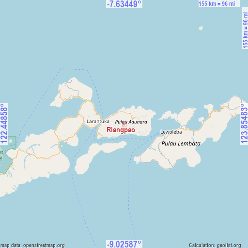
Riangpao GPS coordinates[2]
8° 19' 50.88" South, 123° 9' 6.12" East
| Map corner | latitude | longitude |
|---|---|---|
| Upper-left | -7.63449°, | 122.44858° |
| Center: | -8.3308°, | 123.1517° |
| Lower-right: | -9.02587°, | 123.85483° |
| Map W x H: | 154.7×154.7 km | = 96.1×96.1mi |
| max Lat: | 5.88969° ⇑78.1% North |
| Riangpao: | -8.3308° |
| min Lat: | ⇓21.9% South -10.934° |
| min Long | Riangpao | max Long |
| 95.1345° | 123.1517° | 140.9419° |
| W 90.9%⇐ | ⇒9.1% E |
Elevation
Elevation of Riangpao is 688 m = 2257 ft, and this is 458.3 m = 1504 ft above average elevation for this country.
| Max E: |
3185 m = 10449 ft | 8.6% |
| Riangpao | 688 m 2257 ft | |
| Avg. | 229.7 m = 754 ft | |
Min E: |
-1 m = -3 ft | 91.4% |
See also: Indonesia elevation on elevation.city.
Geographical zone
Riangpao is located in South Torrid zone (between Equator and Tropic of Capricorn). Distance of Equator is 926.3 km =575.6 mi to North.| Distance of | km | miles | from Riangpao |
|---|---|---|---|
| Equator | 926.3 | 575.6 | to North |
| Tropic Capricorn | 1679.6 | 1043.7 | to South |
| Antarctic Circle | 6474.9 | 4023.3 | to South |
| South Pole | 9080.8 | 5642.5 | to South |


Nearby cities:
15 places around Riangpao: (largest is in red/bold)
• Bayuwan
1.6 km =1 mi,  314°
314°
• Era
4.5 km =2.8 mi,  276°
276°
• Ipiebang
4.5 km =2.8 mi,  208°
208°
• Lamaluwo
1.4 km =0.9 mi,  168°
168°
• Leter
3.6 km =2.2 mi,  287°
287°
• Lewonara
3.6 km =2.2 mi,  142°
142°
• Mulawato
0.6 km =0.4 mi,  346°
346°
• Ongabelen
5.5 km =3.4 mi,  94°
94°
• Papilawe
2 km =1.2 mi,  30°
30°
• Riangwerang
5.8 km =3.6 mi,  103°
103°
• Tanahpukang
1.6 km =1 mi, 353°
• Waibereno
2.9 km =1.8 mi,  339°
339°
• Wainira
5.9 km =3.7 mi,  54°
54°
• Watodei
6 km =3.7 mi,  262°
262°
• Wewit
3.3 km =2.1 mi,  10°
10°
Sources, notices
• [Note1] Compared only with cities in Indonesia existing in our database
• [Src1] Map data: © OpenStreetMap contributors (CC-BY-SA)
• [Src2] Other city data from geonames.org with taken over terms of usage.
• [Src3] Geographical zone / Annual Mean Temperature by Robert A. Rohde @ Wikipedia
