Lamaluwo geodata
Lamaluwo (East Nusa Tenggara) is a seat of a fourth-order administrative division; located in Indonesia in Asia/Makassar (GMT+8) time zone. In our database, there are 407 cities with bigger population. Compared to other cities in Indonesia, 78.5% of cities are located further ↑North; 90.9% of cities are located further ←West and 90.4% of cities have lower elevation than Lamaluwo. Note1


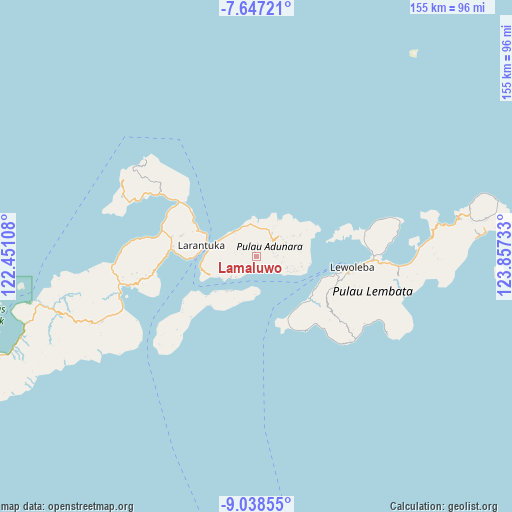
Lamaluwo GPS coordinates[2]
8° 20' 36.6" South, 123° 9' 15.12" East
| Map corner | latitude | longitude |
|---|---|---|
| Upper-left | -7.64721°, | 122.45108° |
| Center: | -8.3435°, | 123.1542° |
| Lower-right: | -9.03855°, | 123.85733° |
| Map W x H: | 154.7×154.7 km | = 96.1×96.1mi |
| max Lat: | 5.88969° ⇑78.5% North |
| Lamaluwo: | -8.3435° |
| min Lat: | ⇓21.5% South -10.934° |
| min Long | Lamaluwo | max Long |
| 95.1345° | 123.1542° | 140.9419° |
| W 90.9%⇐ | ⇒9.1% E |
Elevation
Elevation of Lamaluwo is 656 m = 2152 ft, and this is 426.3 m = 1399 ft above average elevation for this country.
| Max E: |
3185 m = 10449 ft | 9.6% |
| Lamaluwo | 656 m 2152 ft | |
| Avg. | 229.7 m = 754 ft | |
Min E: |
-1 m = -3 ft | 90.4% |
See also: Indonesia elevation on elevation.city.
Geographical zone
Lamaluwo is located in South Torrid zone (between Equator and Tropic of Capricorn). Distance of Equator is 927.7 km =576.4 mi to North.| Distance of | km | miles | from Lamaluwo |
|---|---|---|---|
| Equator | 927.7 | 576.4 | to North |
| Tropic Capricorn | 1678.2 | 1042.8 | to South |
| Antarctic Circle | 6473.5 | 4022.4 | to South |
| South Pole | 9079.4 | 5641.7 | to South |


Nearby cities:
15 places around Lamaluwo: (largest is in red/bold)
• Bayuwan
2.9 km =1.8 mi,  330°
330°
• Era
5.2 km =3.2 mi,  291°
291°
• Ipiebang
3.5 km =2.2 mi,  223°
223°
• Lamahala
5.1 km =3.2 mi,  183°
183°
• Leter
4.5 km =2.8 mi,  303°
303°
• Lewonara
2.4 km =1.5 mi,  126°
126°
• Mulawato
2 km =1.2 mi,  348°
348°
• Papilawe
3.2 km =2 mi,  13°
13°
• Riangpao
1.4 km =0.9 mi, 348°
• Tanahpukang
3.1 km =1.9 mi, 351°
• Waibereno
4.4 km =2.7 mi,  342°
342°
• Waipapan Satu
5.2 km =3.2 mi,  161°
161°
• Waiwerang
5.1 km =3.2 mi,  166°
166°
• Wewit
4.6 km =2.9 mi,  3°
3°
• Wotan
4.7 km =2.9 mi, 167°
Sources, notices
• [Note1] Compared only with cities in Indonesia existing in our database
• [Src1] Map data: © OpenStreetMap contributors (CC-BY-SA)
• [Src2] Other city data from geonames.org with taken over terms of usage.
• [Src3] Geographical zone / Annual Mean Temperature by Robert A. Rohde @ Wikipedia
