Waiwerang geodata
Waiwerang (East Nusa Tenggara) is a seat of a third-order administrative division; located in Indonesia in Asia/Makassar (GMT+8) time zone. In our database, there are 407 cities with bigger population. Compared to other cities in Indonesia, 80% of cities are located further ↑North; 91% of cities are located further ←West and 72.7% of cities have higher elevation than Waiwerang. Note1


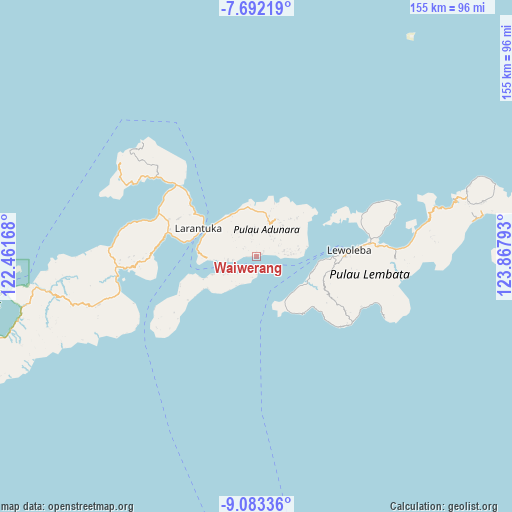
Waiwerang GPS coordinates[2]
8° 23' 18.24" South, 123° 9' 53.28" East
| Map corner | latitude | longitude |
|---|---|---|
| Upper-left | -7.69219°, | 122.46168° |
| Center: | -8.3884°, | 123.1648° |
| Lower-right: | -9.08336°, | 123.86793° |
| Map W x H: | 154.7×154.7 km | = 96.1×96.1mi |
| max Lat: | 5.88969° ⇑80% North |
| Waiwerang: | -8.3884° |
| min Lat: | ⇓20% South -10.934° |
| min Long | Waiwerang | max Long |
| 95.1345° | 123.1648° | 140.9419° |
| W 91%⇐ | ⇒9% E |
Elevation
Elevation of Waiwerang is 28 m = 92 ft, and this is 201.7 m = 662 ft below average elevation for this country.
| Max E: |
3185 m = 10449 ft | 72.7% |
| Avg. | 229.7 m = 754 ft | |
| Waiwerang | 28 m = 92 ft | |
Min E: |
-1 m = -3 ft | 27.3% |
See also: Indonesia elevation on elevation.city.
Geographical zone
Waiwerang is located in South Torrid zone (between Equator and Tropic of Capricorn). Distance of Equator is 932.7 km =579.6 mi to North.| Distance of | km | miles | from Waiwerang |
|---|---|---|---|
| Equator | 932.7 | 579.6 | to North |
| Tropic Capricorn | 1673.2 | 1039.7 | to South |
| Antarctic Circle | 6468.5 | 4019.3 | to South |
| South Pole | 9074.4 | 5638.6 | to South |


Nearby cities:
15 places around Waiwerang: (largest is in red/bold)
• Gorang
5.8 km =3.6 mi,  219°
219°
• Ipiebang
4.3 km =2.7 mi,  304°
304°
• Lamahala
1.5 km =0.9 mi,  265°
265°
• Lamakera Dua
5 km =3.1 mi,  182°
182°
• Lamakera Satu
5.3 km =3.3 mi, 180°
• Lamaluwo
5.1 km =3.2 mi,  346°
346°
• Lewolen
6.8 km =4.2 mi,  47°
47°
• Lewonara
3.6 km =2.2 mi,  12°
12°
• Mulawato
7.1 km =4.4 mi, 347°
• Riangpao
6.6 km =4.1 mi, 347°
• Riangwerang
6.6 km =4.1 mi,  39°
39°
• Terong
2.7 km =1.7 mi,  263°
263°
• Waipapan Satu
0.5 km =0.3 mi,  83°
83°
• Wakapuken
6.8 km =4.2 mi, 41°
• Wotan
0.4 km =0.2 mi,  338°
338°
Sources, notices
• [Note1] Compared only with cities in Indonesia existing in our database
• [Src1] Map data: © OpenStreetMap contributors (CC-BY-SA)
• [Src2] Other city data from geonames.org with taken over terms of usage.
• [Src3] Geographical zone / Annual Mean Temperature by Robert A. Rohde @ Wikipedia
